
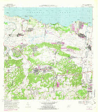
~ Vega Alta PR topo map, 1:20000 scale, 7.5 X 7.5 Minute, Historical, 1969, updated 1983
Vega Alta, Puerto Rico, USGS topographic map dated 1969.
Includes geographic coordinates (latitude and longitude). This topographic map is suitable for hiking, camping, and exploring, or framing it as a wall map.
Printed on-demand using high resolution imagery, on heavy weight and acid free paper, or alternatively on a variety of synthetic materials.
Topos available on paper, Waterproof, Poly, or Tyvek. Usually shipping rolled, unless combined with other folded maps in one order.
- Product Number: USGS-5655074
- Free digital map download (high-resolution, GeoPDF): Vega Alta, Puerto Rico (file size: 21 MB)
- Map Size: please refer to the dimensions of the GeoPDF map above
- Weight (paper map): ca. 55 grams
- Map Type: POD USGS Topographic Map
- Map Series: HTMC
- Map Verison: Historical
- Cell ID: 46712
- Scan ID: 362291
- Imprint Year: 1983
- Woodland Tint: Yes
- Photo Revision Year: 1982
- Aerial Photo Year: 1977
- Edit Year: 1982
- Field Check Year: 1969
- Datum: Puerto Rico
- Map Projection: Polyconic
- Map published by United States Geological Survey
- Map Language: English
- Scanner Resolution: 600 dpi
- Map Cell Name: Vega Alta
- Grid size: 7.5 X 7.5 Minute
- Date on map: 1969
- Map Scale: 1:20000
- Geographical region: Puerto Rico, United States
Neighboring Maps:
All neighboring USGS topo maps are available for sale online at a variety of scales.
Spatial coverage:
Topo map Vega Alta, Puerto Rico, covers the geographical area associated the following places:
- Cerro Gordo - Regadera - Martonnel - Mi Querido Viejo - Dorado del Mar - San Antonio - Sabana - Central Carmen (historical) - Espinosa - Residencial Francisco Vega Sanchez - Villa Santa - Comunidad La Ponderosa - Quintas de Dorado - San José - Costa de Oro - Río Lajas Comunidad - Boulevarda Korea - Toa Alta Zona Urbana - Ceiba Comunidad - Villas de Playa II - Sector Vista Alegre - Santa Rita - Jardines de Toa Alta - Villa Matilde - Paseo de Dorado - Mameyal - San Fernando - La Aldea - Extension Higuillar - Residencial Las Videtas - Vega Alta Zona Urbana - Higuillar - Casa del Rey - Río Lajas - El Coto - Sabana Comunidad - Toa Baja - Breñas Comunidad - Monterrey - San Carlos - Town Hills - Monte Lindo - Monserrate - Costa Dorado - Dorado - Comunidad Carmen - Los Colinas - Brisa del Plata - Dorado Zona Urbana - Villa Amparo - Jardines de Dorado - El Polvorín - Doraville - Reparto Diaz - Los Puertos - San Antonio Comunidad - Minima San Antonio - Brenas - Toa Baja Zona Urbana - Villa Palma - Monserrate Comunidad - Villa Linares - La Inmaculada - Ceiba - Vega Alta - Punto Cubano - La Inmaculada II - Santa Rosa - Boulevarda Vientan
- Map Area ID: AREA18.518.375-66.375-66.25
- Northwest corner Lat/Long code: USGSNW18.5-66.375
- Northeast corner Lat/Long code: USGSNE18.5-66.25
- Southwest corner Lat/Long code: USGSSW18.375-66.375
- Southeast corner Lat/Long code: USGSSE18.375-66.25
- Northern map edge Latitude: 18.5
- Southern map edge Latitude: 18.375
- Western map edge Longitude: -66.375
- Eastern map edge Longitude: -66.25


