
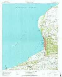
~ Aguadilla PR topo map, 1:20000 scale, 7.5 X 7.5 Minute, Historical, 1960, updated 1983
Aguadilla, Puerto Rico, USGS topographic map dated 1960.
Includes geographic coordinates (latitude and longitude). This topographic map is suitable for hiking, camping, and exploring, or framing it as a wall map.
Printed on-demand using high resolution imagery, on heavy weight and acid free paper, or alternatively on a variety of synthetic materials.
Topos available on paper, Waterproof, Poly, or Tyvek. Usually shipping rolled, unless combined with other folded maps in one order.
- Product Number: USGS-5654550
- Free digital map download (high-resolution, GeoPDF): Aguadilla, Puerto Rico (file size: 29 MB)
- Map Size: please refer to the dimensions of the GeoPDF map above
- Weight (paper map): ca. 55 grams
- Map Type: POD USGS Topographic Map
- Map Series: HTMC
- Map Verison: Historical
- Cell ID: 284
- Scan ID: 362017
- Imprint Year: 1983
- Woodland Tint: Yes
- Visual Version Number: 2
- Edit Year: 1960
- Survey Year: 1937
- Datum: Puerto Rico
- Map Projection: Polyconic
- Map published by United States Geological Survey
- Map Language: English
- Scanner Resolution: 600 dpi
- Map Cell Name: Aguadilla
- Grid size: 7.5 X 7.5 Minute
- Date on map: 1960
- Map Scale: 1:20000
- Geographical region: Puerto Rico, United States
Neighboring Maps:
All neighboring USGS topo maps are available for sale online at a variety of scales.
Spatial coverage:
Topo map Aguadilla, Puerto Rico, covers the geographical area associated the following places:
- Santa Bárbara - Tosquero - Feliciano - Aguada Zona Urbana - Santoni - Tablonal - Monte Mar - Jimenez (historical) - Villa Alegria - Iglesia - Aguadilla Zona Urbana - Aguada - Aguadilla - Caban - Coloso - Residencials Jardines de Aguada - Los Robles - Reparto Los Maestros - Camaceyes - Tamarindo - Alturas de Aguada - Residencial Francisco Egipciaco - Comunidad Palmar Novoa II - Higüey - Cabán Comunidad - San Francisco - Nuevo - Centro Palmar - Reparto Minerva - Monte Real - Comunidad Palmer Noroa - Sector Casualidad - Maleza - Victoria - San Cristobal - Tosquero (historical)
- Map Area ID: AREA18.516666718.375-67.25-67.125
- Northwest corner Lat/Long code: USGSNW18.5166667-67.25
- Northeast corner Lat/Long code: USGSNE18.5166667-67.125
- Southwest corner Lat/Long code: USGSSW18.375-67.25
- Southeast corner Lat/Long code: USGSSE18.375-67.125
- Northern map edge Latitude: 18.5166667
- Southern map edge Latitude: 18.375
- Western map edge Longitude: -67.25
- Eastern map edge Longitude: -67.125


