
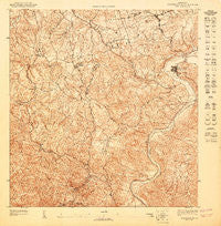
~ Aguas Buenas NE PR topo map, 1:10000 scale, 3.75 X 3.75 Minute, Historical, 1947
Aguas Buenas NE, Puerto Rico, USGS topographic map dated 1947.
Includes geographic coordinates (latitude and longitude). This topographic map is suitable for hiking, camping, and exploring, or framing it as a wall map.
Printed on-demand using high resolution imagery, on heavy weight and acid free paper, or alternatively on a variety of synthetic materials.
Topos available on paper, Waterproof, Poly, or Tyvek. Usually shipping rolled, unless combined with other folded maps in one order.
- Product Number: USGS-5654012
- Free digital map download (high-resolution, GeoPDF): Aguas Buenas NE, Puerto Rico (file size: 21 MB)
- Map Size: please refer to the dimensions of the GeoPDF map above
- Weight (paper map): ca. 55 grams
- Map Type: POD USGS Topographic Map
- Map Series: HTMC
- Map Verison: Historical
- Cell ID: 107527
- Scan ID: 361921
- Survey Year: 1943
- Datum: Unstated
- Map Projection: Polyconic
- Map published by United States Geological Survey
- Map Language: Spanish
- Scanner Resolution: 600 dpi
- Map Cell Name: Aguas Buenas NE
- Grid size: 3.75 X 3.75 Minute
- Date on map: 1947
- Map Scale: 1:10000
- Geographical region: Puerto Rico, United States
Neighboring Maps:
All neighboring USGS topo maps are available for sale online at a variety of scales.
Spatial coverage:
Topo map Aguas Buenas NE, Puerto Rico, covers the geographical area associated the following places:
- Leprocomio - Barriada San Nicholas - Pueblo Seco - Colinas de Fair View - Los Claveles - Carraizo Alto - Paseo Las Vistas - Reparto San Rafael - La Alborada - Sagrado Corazón - Paseo Alta - Lomas de Santa Marta - El Mirador - Terazas de Cupey - Reparto San Rafael - Quebrada Colorado - Pedro Regalado Diaz - Daney - Golden Hill - La Lomita - Paseo Mayor - Bosque de Rio - Alturas de Cupey - Villa Escondida - Alturas de Fairview - El Conquistador - Paseo del Prado - Gruta de Lourdes - Las Cuevas - Residencial Interamericana - Mansiones de Rio Piedras - Ciudad Universitaria - Colinas de Curry - Sunville - Los Cedros - Riveras de Cupey - Rincon Espanol - Lomas de Trujillo Alto - Fairview - Paseo Las Brisa - Paseo Real - Cupey Gardens - Rio Cristal - Saint Just - Trujillo Alto Zona Urbana - Round Hill - Litheda - El Senorial - Alturas de Inter-Americana - San Rafael - Trujillo Alto - Los Choferes - La Marina - San Gerardo
- Map Area ID: AREA18.37518.3125-66.0625-66
- Northwest corner Lat/Long code: USGSNW18.375-66.0625
- Northeast corner Lat/Long code: USGSNE18.375-66
- Southwest corner Lat/Long code: USGSSW18.3125-66.0625
- Southeast corner Lat/Long code: USGSSE18.3125-66
- Northern map edge Latitude: 18.375
- Southern map edge Latitude: 18.3125
- Western map edge Longitude: -66.0625
- Eastern map edge Longitude: -66


