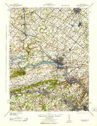
~ Norristown PA topo map, 1:62500 scale, 15 X 15 Minute, Historical, 1943
Norristown, Pennsylvania, USGS topographic map dated 1943.
Includes geographic coordinates (latitude and longitude). This topographic map is suitable for hiking, camping, and exploring, or framing it as a wall map.
Printed on-demand using high resolution imagery, on heavy weight and acid free paper, or alternatively on a variety of synthetic materials.
Topos available on paper, Waterproof, Poly, or Tyvek. Usually shipping rolled, unless combined with other folded maps in one order.
- Product Number: USGS-5931453
- Free digital map download (high-resolution, GeoPDF): Norristown, Pennsylvania (file size: 11 MB)
- Map Size: please refer to the dimensions of the GeoPDF map above
- Weight (paper map): ca. 55 grams
- Map Type: POD USGS Topographic Map
- Map Series: HTMC
- Map Verison: Historical
- Cell ID: 60312
- Scan ID: 461872
- Woodland Tint: Yes
- Aerial Photo Year: 1940
- Datum: NAD
- Map Projection: Polyconic
- Map published by United States Army Corps of Engineers
- Map published by United States Army
- Map published by United States Department of War
- Map Language: English
- Scanner Resolution: 600 dpi
- Map Cell Name: Norristown
- Grid size: 15 X 15 Minute
- Date on map: 1943
- Map Scale: 1:62500
- Geographical region: Pennsylvania, United States
Neighboring Maps:
All neighboring USGS topo maps are available for sale online at a variety of scales.
Spatial coverage:
Topo map Norristown, Pennsylvania, covers the geographical area associated the following places:
- Eagleville - Glenn Rose - Hollis Hills - Daylesford - Plymouth Meadows - Penn Brooke Gardens - Cathcart Manor - Audubon Shrine - Skippack - Norriton East - Calmensin - The Commons at Valley Forge - Schwenfield Manor - Lucon - Belmont Terrace - Bob White Farms - Pawling Woods - Rosemont - Corsons - Andorra Springs - Cedars - Harley Corners - Evansburg Crossing - Mill Grove - Fairview Village - Gypsy Rose Estates - Rolling Meadow Estates - Daylesford Lake - Valley Hi East - Upper Fairview - Trappe Meadows - Ivy Rock - Bethel Hill - Brittany Pointe Estates - Bayhill - Willowyck - Winding Brook Estates - Rahns - Paoli Manor - West Norriton - Haverford - Colonial Way - Audubon Gardens - DeKalb Farms - The Reserve at Lafayette Springs - Collegeville Glen - Providence Crossing - Merion Hills - Ernest - Harmonville - Leopard - Pennypacker Road - Fox Fields - Whitpain Woods - Providence Ridge - Mogeetown - Wissahickon Park Gardens - Perkiomen Woods - Gwynedd - Arbors at Providence - Trappe - Valentine Estates - Treyburn - Norris Hills Court - Cassel Mill Farms - Washington Park - Inglewood - West Wayne - Blue Bell Square - Trent Manor - Radnor Crossing - Crestview at Skippack - Town Court - Forge Spring Village - Penn Brooke - Henderson Park - Audobon Gardens - Wetherills Corner - Springtown - Cambridge Knoll - Whitpain Manor - Merrybrook - Villa of Flair Skippack Village - Gladwyne - Crestwyck - The Estates of Audubon South - The Meadows at Providence Reserve - Valley Forge Woods - Stuarts Keep - Marble Hall - Kings Manor - Leopard Farms - Crooked Lane Crossing - Collegeville Arms - Providence View - Trinity House - Harrison Estate - Cherry Dale - Ironbridge Estates - Jeffersonville
- Map Area ID: AREA40.2540-75.5-75.25
- Northwest corner Lat/Long code: USGSNW40.25-75.5
- Northeast corner Lat/Long code: USGSNE40.25-75.25
- Southwest corner Lat/Long code: USGSSW40-75.5
- Southeast corner Lat/Long code: USGSSE40-75.25
- Northern map edge Latitude: 40.25
- Southern map edge Latitude: 40
- Western map edge Longitude: -75.5
- Eastern map edge Longitude: -75.25

