
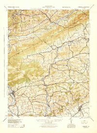
~ Hamburg PA topo map, 1:62500 scale, 15 X 15 Minute, Historical, 1944, updated 1945
Hamburg, Pennsylvania, USGS topographic map dated 1944.
Includes geographic coordinates (latitude and longitude). This topographic map is suitable for hiking, camping, and exploring, or framing it as a wall map.
Printed on-demand using high resolution imagery, on heavy weight and acid free paper, or alternatively on a variety of synthetic materials.
Topos available on paper, Waterproof, Poly, or Tyvek. Usually shipping rolled, unless combined with other folded maps in one order.
- Product Number: USGS-5931225
- Free digital map download (high-resolution, GeoPDF): Hamburg, Pennsylvania (file size: 9 MB)
- Map Size: please refer to the dimensions of the GeoPDF map above
- Weight (paper map): ca. 55 grams
- Map Type: POD USGS Topographic Map
- Map Series: HTMC
- Map Verison: Historical
- Cell ID: 55016
- Scan ID: 461749
- Imprint Year: 1945
- Woodland Tint: Yes
- Aerial Photo Year: 1939
- Survey Year: 1909
- Datum: NAD
- Map Projection: Polyconic
- Map published by United States Army Corps of Engineers
- Map published by United States Army
- Map published by United States Department of War
- Map Language: English
- Scanner Resolution: 600 dpi
- Map Cell Name: Hamburg
- Grid size: 15 X 15 Minute
- Date on map: 1944
- Map Scale: 1:62500
- Geographical region: Pennsylvania, United States
Neighboring Maps:
All neighboring USGS topo maps are available for sale online at a variety of scales.
Spatial coverage:
Topo map Hamburg, Pennsylvania, covers the geographical area associated the following places:
- Raberts Corner - Klinesville - Dreibelbis - Stony Run - Hamburg Heights - Lynnville - Wanamakers - Mosserville - Mantz - Chain - Lynnport - Kempton - Pleasant Hills Trailer Park - Webster - Leibeyville - Highland Estates Mobile Home Park - Dorset - Jacksonville - Stines Corner - Moselem - New Ringgold - Rene Mont - Fetherolfsville - Reynolds - Grimville - Virginville - Kepner - Slateville - Steinsville - Eckville - Windsor Castle - Lenhartsville - Snyders - Five Locks - Mengel - Rauschs - New Tripoli - Shoemakersville - Millers - Quaker City - Hamburg - Albany - Schneidersville - Krumsville - West Penn - Edenburg - Kutztown - Greenawald - Eagle Point - Trexler
- Map Area ID: AREA40.7540.5-76-75.75
- Northwest corner Lat/Long code: USGSNW40.75-76
- Northeast corner Lat/Long code: USGSNE40.75-75.75
- Southwest corner Lat/Long code: USGSSW40.5-76
- Southeast corner Lat/Long code: USGSSE40.5-75.75
- Northern map edge Latitude: 40.75
- Southern map edge Latitude: 40.5
- Western map edge Longitude: -76
- Eastern map edge Longitude: -75.75


