
~ Harrisburg PA topo map, 1:250000 scale, 1 X 2 Degree, Historical, 1957, updated 1988
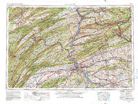
Harrisburg, Pennsylvania, USGS topographic map dated 1957.
Includes geographic coordinates (latitude and longitude). This topographic map is suitable for hiking, camping, and exploring, or framing it as a wall map.
Printed on-demand using high resolution imagery, on heavy weight and acid free paper, or alternatively on a variety of synthetic materials.
Topos available on paper, Waterproof, Poly, or Tyvek. Usually shipping rolled, unless combined with other folded maps in one order.
- Product Number: USGS-5332040
- Free digital map download (high-resolution, GeoPDF): Harrisburg, Pennsylvania (file size: 16 MB)
- Map Size: please refer to the dimensions of the GeoPDF map above
- Weight (paper map): ca. 55 grams
- Map Type: POD USGS Topographic Map
- Map Series: HTMC
- Map Verison: Historical
- Cell ID: 68815
- Scan ID: 707387
- Imprint Year: 1988
- Woodland Tint: Yes
- Aerial Photo Year: 1952
- Edit Year: 1969
- Field Check Year: 1957
- Datum: NAD27
- Map Projection: Transverse Mercator
- Map published by United States Geological Survey
- Map Language: English
- Scanner Resolution: 508 dpi
- Map Cell Name: Harrisburg
- Grid size: 1 X 2 Degree
- Date on map: 1957
- Map Scale: 1:250000
- Geographical region: Pennsylvania, United States
Neighboring Maps:
All neighboring USGS topo maps are available for sale online at a variety of scales.
Spatial coverage:
Topo map Harrisburg, Pennsylvania, covers the geographical area associated the following places:
- Freeburg - Old Fort - New Mines - Willow Lake - Fair Acres - Fannettsburg - New Milltown - Molino - Carsonville - Silver Ford Heights - Springville - Nauvoo - Cabel - Pogue - Emigsville - Naumanstown - Shenandoah - Lititz - Weston Place - Adamstown - Glen Moore - Colyer - Monticello - Centerville - Smullton - Bloomsdorf - Reed - Elstonville - Sand Beach - Terre Hill - Beaufort Farms - Phoebe Berks Village - Numidia - Pleasant Hill - Decorum - Kulp - Hoffer - Swengel - Mount Pleasant - Red Cross - Lemoyne - Laurel Junction - Decatur - Mount Hope - Pine Junction - Hanover Heights - Garden Hills - Piketown - Greenland - Port Trevorton - Winfield - Rose Glen - Lake Wynonah - Fisherville - Big Spring - Edisonville - Centre Hall - Mount Carbon - Millway - Toland - Mill Creek - Port Ann - Detters Mill - Zerby - Panorama Village - New Castle - Toftrees - Mahantango - Kinkora Heights - Drytown - Plainfield - North View Hills - Enders - Greenridge - Lithia Springs - Colonial Terrace - Wellsville - West Lebanon - Dover - Rheems - Victoria Furnace - Cressona - Dogtown - Hawstone - Westmont - Port Clinton - Brockton - Carlisle Junction - Beavertown - Mexico - Leidighs - Lucy Furnace - Sharpsburg - Shoentown - Colonial Hills - Union Mills - Eshcol - Paxton Acres - Wertzville - Rockville
- Map Area ID: AREA4140-78-76
- Northwest corner Lat/Long code: USGSNW41-78
- Northeast corner Lat/Long code: USGSNE41-76
- Southwest corner Lat/Long code: USGSSW40-78
- Southeast corner Lat/Long code: USGSSE40-76
- Northern map edge Latitude: 41
- Southern map edge Latitude: 40
- Western map edge Longitude: -78
- Eastern map edge Longitude: -76


