
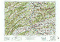
~ Harrisburg PA topo map, 1:250000 scale, 1 X 2 Degree, Historical, 1957, updated 1988
Harrisburg, Pennsylvania, USGS topographic map dated 1957.
Includes geographic coordinates (latitude and longitude). This topographic map is suitable for hiking, camping, and exploring, or framing it as a wall map.
Printed on-demand using high resolution imagery, on heavy weight and acid free paper, or alternatively on a variety of synthetic materials.
Topos available on paper, Waterproof, Poly, or Tyvek. Usually shipping rolled, unless combined with other folded maps in one order.
- Product Number: USGS-5332038
- Free digital map download (high-resolution, GeoPDF): Harrisburg, Pennsylvania (file size: 22 MB)
- Map Size: please refer to the dimensions of the GeoPDF map above
- Weight (paper map): ca. 55 grams
- Map Type: POD USGS Topographic Map
- Map Series: HTMC
- Map Verison: Historical
- Cell ID: 68815
- Scan ID: 223164
- Imprint Year: 1988
- Woodland Tint: Yes
- Visual Version Number: 2
- Photo Revision Year: 1969
- Aerial Photo Year: 1952
- Field Check Year: 1957
- Datum: NAD27
- Map Projection: Transverse Mercator
- Map published by: Military, Other
- Map Language: English
- Scanner Resolution: 600 dpi
- Map Cell Name: Harrisburg
- Grid size: 1 X 2 Degree
- Date on map: 1957
- Map Scale: 1:250000
- Geographical region: Pennsylvania, United States
Neighboring Maps:
All neighboring USGS topo maps are available for sale online at a variety of scales.
Spatial coverage:
Topo map Harrisburg, Pennsylvania, covers the geographical area associated the following places:
- Hinkletown - Sporting Hill - Harris Acres - Lykens - Brooklawn - Mentzer - Fisherdale - Craighead - Silver Ford Heights - Rutherford Gardens - Willow Hill - Vulcan - Woodside - Spring Dale Heights - Shingletown - Snydertown - Zion - West Lampeter - Rock Glen - Ringtown - Alexander Springs - Stone Glen - Leaman Place - De Turksville - Nossville - Locust Grove - Belmont - Mifflin - Cornwall Terrace - Locust Ridge Manor - Manada Gap - Pardee - Mainsville - Bailey - Orwigsburg - Cornwall - Houserville - Longsdorf - McGillstown - Bernville - Vintage Station - Dunkelbergers - Newtown - Rheems - Marion Heights - Wagner - Mount Hope - Gowen - Fivepointville - Country Club Estates - Dietrich - Conewago Heights - Maryd - Mount Wolf - Manadahill - Oakland Mills - Shoemakers - Concord - Westfield Terrace - Spring Mills - Valley Green Estates - Donerville - Hebron - Bloomingdale - Hustons Mill - Landisburg - Port Trevorton - Beverly Estates - Mount Zion - Elizabethville - Mechanicsville - Intercourse - Phoenix Park - Fairview Park - Inglenook - Sacramento - Fox Chase - Hummels Wharf - Dogtown - Reed - Fairland - Rager Summit - Enders - Fort Couch - Snufftown - Honey - Yoder Heights - Napiersville - Weavertown - Glendower - Asherton - Mooredale - Newton Junction - Carroll Manor - Glen Moore - Steelton - Garden View - Holiday Park - Carlisle Springs - Paxton Acres
- Map Area ID: AREA4140-78-76
- Northwest corner Lat/Long code: USGSNW41-78
- Northeast corner Lat/Long code: USGSNE41-76
- Southwest corner Lat/Long code: USGSSW40-78
- Southeast corner Lat/Long code: USGSSE40-76
- Northern map edge Latitude: 41
- Southern map edge Latitude: 40
- Western map edge Longitude: -78
- Eastern map edge Longitude: -76


