
~ Harrisburg PA topo map, 1:250000 scale, 1 X 2 Degree, Historical, 1957, updated 1973
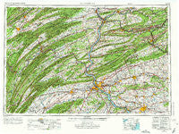
Harrisburg, Pennsylvania, USGS topographic map dated 1957.
Includes geographic coordinates (latitude and longitude). This topographic map is suitable for hiking, camping, and exploring, or framing it as a wall map.
Printed on-demand using high resolution imagery, on heavy weight and acid free paper, or alternatively on a variety of synthetic materials.
Topos available on paper, Waterproof, Poly, or Tyvek. Usually shipping rolled, unless combined with other folded maps in one order.
- Product Number: USGS-5332032
- Free digital map download (high-resolution, GeoPDF): Harrisburg, Pennsylvania (file size: 21 MB)
- Map Size: please refer to the dimensions of the GeoPDF map above
- Weight (paper map): ca. 55 grams
- Map Type: POD USGS Topographic Map
- Map Series: HTMC
- Map Verison: Historical
- Cell ID: 68815
- Scan ID: 171812
- Imprint Year: 1973
- Woodland Tint: Yes
- Photo Revision Year: 1969
- Aerial Photo Year: 1969
- Field Check Year: 1957
- Datum: Unstated
- Map Projection: Transverse Mercator
- Map published by: Military, Other
- Map Language: English
- Scanner Resolution: 600 dpi
- Map Cell Name: Harrisburg
- Grid size: 1 X 2 Degree
- Date on map: 1957
- Map Scale: 1:250000
- Geographical region: Pennsylvania, United States
Neighboring Maps:
All neighboring USGS topo maps are available for sale online at a variety of scales.
Spatial coverage:
Topo map Harrisburg, Pennsylvania, covers the geographical area associated the following places:
- Green Valley Gardens - Gimberlings Mill - Brownstown - Union Grove - Cowans Village - Bunker Hill - Pine Grove Furnace - Oberlin Gardens - Beverly Heights - Ephrata - Kistler - Washington - Laurel Grove - Colonial Hills - Lebanon Independent - Oak Hall - Wolfs Store - Excelsior - Loysville - Springville - Blossom Hill - Seyoc - Weavertown - Shumans - Boggstown - Dornsife - Troxelville - Fairbrook - Greenland - Kimberly Meadows - Mowry - Uriah - Zerby - Malta - Woodridge Estates - Colonial Woods - Decatur - Oaklyn - Linville Circle - Summerdale - Woodland - Brandtsville - Aristes - Pleasant Hills - West Ridge - Andersontown - Pansy Hill - Weishample - Fishers Ferry - Duncott - Union Mills - Morea - Berrysburg - Vaughn - Maddensville - Ridgeview - Vandyke - Waynesboro - New Berlin - Ryde - Rheems - Dooleyville - Kutztown - Hillside Village - Killinger - Bucknell - Penbrook - Cottage - Swartzville - Cornwall - Shirleysburg - Mount Rock - Lewistown - Coleville - Glenvale - Derringer - Wellsville - Cobblesville - Juniata Terrace - Reinholds - Akron - Harrisburg - Spechty Kopf - Rausch Creek - Falmouth - Vulcan - Sporting Hill - Chestnut Hill - Mechanicsville - Ferndale - Pattersonville - Homewood - Cameron - Rowenna - Bernville - Donnellytown - Lost Creek - Center Square - Forest Hill - Mount Top
- Map Area ID: AREA4140-78-76
- Northwest corner Lat/Long code: USGSNW41-78
- Northeast corner Lat/Long code: USGSNE41-76
- Southwest corner Lat/Long code: USGSSW40-78
- Southeast corner Lat/Long code: USGSSE40-76
- Northern map edge Latitude: 41
- Southern map edge Latitude: 40
- Western map edge Longitude: -78
- Eastern map edge Longitude: -76


