
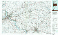
~ Harrisburg PA topo map, 1:100000 scale, 30 X 60 Minute, Historical, 1984, updated 1985
Harrisburg, Pennsylvania, USGS topographic map dated 1984.
Includes geographic coordinates (latitude and longitude). This topographic map is suitable for hiking, camping, and exploring, or framing it as a wall map.
Printed on-demand using high resolution imagery, on heavy weight and acid free paper, or alternatively on a variety of synthetic materials.
Topos available on paper, Waterproof, Poly, or Tyvek. Usually shipping rolled, unless combined with other folded maps in one order.
- Product Number: USGS-5331954
- Free digital map download (high-resolution, GeoPDF): Harrisburg, Pennsylvania (file size: 20 MB)
- Map Size: please refer to the dimensions of the GeoPDF map above
- Weight (paper map): ca. 55 grams
- Map Type: POD USGS Topographic Map
- Map Series: HTMC
- Map Verison: Historical
- Cell ID: 67639
- Scan ID: 223170
- Imprint Year: 1985
- Aerial Photo Year: 1983
- Edit Year: 1984
- Datum: NAD27
- Map Projection: Universal Transverse Mercator
- Planimetric: Yes
- Map published by United States Geological Survey
- Map Language: English
- Scanner Resolution: 600 dpi
- Map Cell Name: Harrisburg
- Grid size: 30 X 60 Minute
- Date on map: 1984
- Map Scale: 1:100000
- Geographical region: Pennsylvania, United States
Neighboring Maps:
All neighboring USGS topo maps are available for sale online at a variety of scales.
Spatial coverage:
Topo map Harrisburg, Pennsylvania, covers the geographical area associated the following places:
- Coffeetown - Burd Coleman Village - Salisbury Heights - Millbach Springs - Piketown - Bausman - Nauvoo - Glades - Roseville - Waltonville - Kutztown - Prescott - Quaker Village - Frysville - Clearview - Weavertown - East Earl - Beverly Heights - Winding Heights - Goodville - Weidmanville - Reesers Summit - Raven Hill - Bowmansdale - McGovernsville - Avon - Flintville - Roseville - Mascot - Perdix - Midway - Lakeview Heights - Rossmoyne - Cocalico House - Mount Airy - Pansy Hill - Meckville - Poplar Gardens - Redland Village - Country Club West - Coxtown (historical) - Anthracite - Schubert - Cornwall - Glen Moore - Shreiners - Pine Acres - Manada Gap - Penryn - Stafford Heights - Grantham - Bellegrove - Yocumtown - Fredericksburg - Mechanicsville - Willow Farms Mobile Home Park - Sherwood Park - Royalton - Wheatland - Beverly - Coheva - Bainbridge - Penn Rose Park - Greble - Fair Acres - Grings Hill Estates - Spring Valley - Colonial Terrace - Roler - Bamford - Club Estates - Chickies - Highland - Millport - Winding Hill - Valley Green - East Hanover - Spring Run Manor - Paxtang Manor - Heilmandale - Pleasant Hills - Quaker Hills - Long Lane Acres - Host - Oakmont - Colonial Woods - Oyster Point - Crest View - Cordelia - Green Bank - Intercourse - Stevenstown - Hayshire - Locust Lane Acres - Green Lane Farms - West Lancaster - Concord - Montgomery Ferry - New Shaefferstown - Hunsecker
- Map Area ID: AREA40.540-77-76
- Northwest corner Lat/Long code: USGSNW40.5-77
- Northeast corner Lat/Long code: USGSNE40.5-76
- Southwest corner Lat/Long code: USGSSW40-77
- Southeast corner Lat/Long code: USGSSE40-76
- Northern map edge Latitude: 40.5
- Southern map edge Latitude: 40
- Western map edge Longitude: -77
- Eastern map edge Longitude: -76


