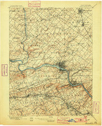
~ Norristown PA topo map, 1:62500 scale, 15 X 15 Minute, Historical, 1895, updated 1901
Norristown, Pennsylvania, USGS topographic map dated 1895.
Includes geographic coordinates (latitude and longitude). This topographic map is suitable for hiking, camping, and exploring, or framing it as a wall map.
Printed on-demand using high resolution imagery, on heavy weight and acid free paper, or alternatively on a variety of synthetic materials.
Topos available on paper, Waterproof, Poly, or Tyvek. Usually shipping rolled, unless combined with other folded maps in one order.
- Product Number: USGS-5331076
- Free digital map download (high-resolution, GeoPDF): Norristown, Pennsylvania (file size: 9 MB)
- Map Size: please refer to the dimensions of the GeoPDF map above
- Weight (paper map): ca. 55 grams
- Map Type: POD USGS Topographic Map
- Map Series: HTMC
- Map Verison: Historical
- Cell ID: 60312
- Scan ID: 169901
- Imprint Year: 1901
- Survey Year: 1894
- Datum: Unstated
- Map Projection: Unstated
- Map published by United States Geological Survey
- Map Language: English
- Scanner Resolution: 600 dpi
- Map Cell Name: Norristown
- Grid size: 15 X 15 Minute
- Date on map: 1895
- Map Scale: 1:62500
- Geographical region: Pennsylvania, United States
Neighboring Maps:
All neighboring USGS topo maps are available for sale online at a variety of scales.
Spatial coverage:
Topo map Norristown, Pennsylvania, covers the geographical area associated the following places:
- Estates at Whitemarsh - Haverford Village - Hidden Valley - Brittains Corner - Mill Road - Eagel Stream - Olde Village - Berwyn - Valley Forge Estates - Blue Bell Farms - Belfry Meadow - Wynwood Estates - Chapel View Estates - Cannon Run West - Corsons - Trappe - Valley Forge Mountain North - Mechanicsville - Ernest - Cedars - Thomas Wynne - Gwynedd Chase - West Point - Cambridge Knoll - Blue Bell Square - Kerwood - Coldspring Crossing - Kings Manor - School Side Manor - Wissahickon Park Gardens - Palm Beach Farm - Washingtons Crossing - Valley Forge Towers - Black Horse - Abruzzi Estates - Waynewoods - Springtown - Inglewood Gardens - Wooded Glen - Plymouth Meadows - Haverford - Bethel Grant - The Reserve at Lafayette Springs - Meadow Wick - Harley Corners - Swedesburg - The Mermont - Moister Tract - Trappe Meadows - Upper Fairview - Creamery - Valley Forge - Pin Oak Estates - Five Points - Chesterbrook - Deepdale - Gwynedd Woods - Crooked Lane Crossing - Villanova - Norristown - Inglewood - Skippack Ridge - Hollis Hills - Norris Hills Court - Providence Crossing - Iron Bridge Estates - Aronwold - Greenview Estates - Arcola - Bayhill - Whitehorse Farms - Continental Arms - Executive House (subdivision) - Dekalb Park - Swedeland - Gleneagles - Village Builders - Normandy Farms Estates - Far-A-Field - Devon - Betzwood - Towamencin Village - Perkiomen Greene - Hillcrest Meadows - Wyola - Washington Park - Collegeville Crossing - Grand View Heights - Calmensin - Norlynne Court - Harrison Estate - Fox Fields - Oxford Manor - Freedom View - Birkdale - Cathcart Manor - Paoli - Duffryn Mawr - Cherry Dale - Estates at Collegeville
- Map Area ID: AREA40.2540-75.5-75.25
- Northwest corner Lat/Long code: USGSNW40.25-75.5
- Northeast corner Lat/Long code: USGSNE40.25-75.25
- Southwest corner Lat/Long code: USGSSW40-75.5
- Southeast corner Lat/Long code: USGSSE40-75.25
- Northern map edge Latitude: 40.25
- Southern map edge Latitude: 40
- Western map edge Longitude: -75.5
- Eastern map edge Longitude: -75.25

