
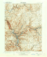
~ Johnstown PA topo map, 1:62500 scale, 15 X 15 Minute, Historical, 1904, updated 1965
Johnstown, Pennsylvania, USGS topographic map dated 1904.
Includes geographic coordinates (latitude and longitude). This topographic map is suitable for hiking, camping, and exploring, or framing it as a wall map.
Printed on-demand using high resolution imagery, on heavy weight and acid free paper, or alternatively on a variety of synthetic materials.
Topos available on paper, Waterproof, Poly, or Tyvek. Usually shipping rolled, unless combined with other folded maps in one order.
- Product Number: USGS-5330490
- Free digital map download (high-resolution, GeoPDF): Johnstown, Pennsylvania (file size: 9 MB)
- Map Size: please refer to the dimensions of the GeoPDF map above
- Weight (paper map): ca. 55 grams
- Map Type: POD USGS Topographic Map
- Map Series: HTMC
- Map Verison: Historical
- Cell ID: 55899
- Scan ID: 171095
- Imprint Year: 1965
- Survey Year: 1904
- Datum: NAD27
- Map Projection: Polyconic
- Map published by United States Geological Survey
- Map Language: English
- Scanner Resolution: 600 dpi
- Map Cell Name: Johnstown
- Grid size: 15 X 15 Minute
- Date on map: 1904
- Map Scale: 1:62500
- Geographical region: Pennsylvania, United States
Neighboring Maps:
All neighboring USGS topo maps are available for sale online at a variety of scales.
Spatial coverage:
Topo map Johnstown, Pennsylvania, covers the geographical area associated the following places:
- Creslo - Wehrum - Belmont - Revloc - Krings - Cambria City - Moxham - New Germany - Parkhill - Cramer - Bon Air - Geistown - Saint Michael - Prospect - Wesley Chapel - Riverside - Cover Hill - Elton - Nanty Glo - Dale - Tire Hill - Summerhill - East Conemaugh - Soukesburg - Lorain - Southmont - Bens Creek - Daisytown - Wissingertown - Rexis - Brownstown - South Fork - Number Thirty-Seven - Stonycreek - Woodvale - Echo - Newtown - Ehrenfeld - Fishertown - Walnut Grove - Westmont - Kernville - Vinco - Mundys Corner - Johnstown - Ferndale - Ingleside - Goods Corner - Pleasant Hill - Coopersdale - Twin Rocks - Beula - Elim - Roxbury - Cardiff - Mineral Point - Walsall - Salix - Chickaree - Parkstown - West Point - Franklin - Minersville - Oakhurst - Rockville - Vintondale - Oakland - Conemaugh - Hornerstown
- Map Area ID: AREA40.540.25-79-78.75
- Northwest corner Lat/Long code: USGSNW40.5-79
- Northeast corner Lat/Long code: USGSNE40.5-78.75
- Southwest corner Lat/Long code: USGSSW40.25-79
- Southeast corner Lat/Long code: USGSSE40.25-78.75
- Northern map edge Latitude: 40.5
- Southern map edge Latitude: 40.25
- Western map edge Longitude: -79
- Eastern map edge Longitude: -78.75


