
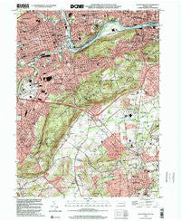
~ Allentown East PA topo map, 1:24000 scale, 7.5 X 7.5 Minute, Historical, 1999, updated 2001
Allentown East, Pennsylvania, USGS topographic map dated 1999.
Includes geographic coordinates (latitude and longitude). This topographic map is suitable for hiking, camping, and exploring, or framing it as a wall map.
Printed on-demand using high resolution imagery, on heavy weight and acid free paper, or alternatively on a variety of synthetic materials.
Topos available on paper, Waterproof, Poly, or Tyvek. Usually shipping rolled, unless combined with other folded maps in one order.
- Product Number: USGS-5321700
- Free digital map download (high-resolution, GeoPDF): Allentown East, Pennsylvania (file size: 16 MB)
- Map Size: please refer to the dimensions of the GeoPDF map above
- Weight (paper map): ca. 55 grams
- Map Type: POD USGS Topographic Map
- Map Series: HTMC
- Map Verison: Historical
- Cell ID: 624
- Scan ID: 223370
- Imprint Year: 2001
- Woodland Tint: Yes
- Aerial Photo Year: 1999
- Field Check Year: 1964
- Datum: NAD83
- Map Projection: Universal Transverse Mercator
- Map published by United States Geological Survey
- Map Language: English
- Scanner Resolution: 600 dpi
- Map Cell Name: Allentown East
- Grid size: 7.5 X 7.5 Minute
- Date on map: 1999
- Map Scale: 1:24000
- Geographical region: Pennsylvania, United States
Neighboring Maps:
All neighboring USGS topo maps are available for sale online at a variety of scales.
Spatial coverage:
Topo map Allentown East, Pennsylvania, covers the geographical area associated the following places:
- Farmington - Star Village - Seidersville - Hanover Acres - Emmaus - Mountainville - Waldheim Park - Wilbur - Limeport - Allentown - University Heights - Ritterville - Wydnor - Lanark - East Allentown - Fountain Hill - Gauff Hill - Friedensville - Summit Lawn - Alton Park - Overlook Springs - Coopersburg - Center Valley - Emmaus Junction - Colesville - Vera Cruz - Vera Cruz Station - Saucon Valley
- Map Area ID: AREA40.62540.5-75.5-75.375
- Northwest corner Lat/Long code: USGSNW40.625-75.5
- Northeast corner Lat/Long code: USGSNE40.625-75.375
- Southwest corner Lat/Long code: USGSSW40.5-75.5
- Southeast corner Lat/Long code: USGSSE40.5-75.375
- Northern map edge Latitude: 40.625
- Southern map edge Latitude: 40.5
- Western map edge Longitude: -75.5
- Eastern map edge Longitude: -75.375


