
~ Brogan OR topo map, 1:100000 scale, 30 X 60 Minute, Historical, 1980, updated 1997
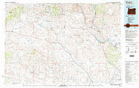
Brogan, Oregon, USGS topographic map dated 1980.
Includes geographic coordinates (latitude and longitude). This topographic map is suitable for hiking, camping, and exploring, or framing it as a wall map.
Printed on-demand using high resolution imagery, on heavy weight and acid free paper, or alternatively on a variety of synthetic materials.
Topos available on paper, Waterproof, Poly, or Tyvek. Usually shipping rolled, unless combined with other folded maps in one order.
- Product Number: USGS-5545672
- Free digital map download (high-resolution, GeoPDF): Brogan, Oregon (file size: 28 MB)
- Map Size: please refer to the dimensions of the GeoPDF map above
- Weight (paper map): ca. 55 grams
- Map Type: POD USGS Topographic Map
- Map Series: HTMC
- Map Verison: Historical
- Cell ID: 72143
- Scan ID: 283056
- Imprint Year: 1997
- Woodland Tint: Yes
- Aerial Photo Year: 1977
- Edit Year: 1980
- Datum: NAD27
- Map Projection: Universal Transverse Mercator
- Map published by United States Geological Survey
- Map Language: English
- Scanner Resolution: 600 dpi
- Map Cell Name: Brogan
- Grid size: 30 X 60 Minute
- Date on map: 1980
- Map Scale: 1:100000
- Geographical region: Oregon, United States
Neighboring Maps:
All neighboring USGS topo maps are available for sale online at a variety of scales.
Spatial coverage:
Topo map Brogan, Oregon, covers the geographical area associated the following places:
- Rye Valley - Dennis - China Town - Brogan - Ontario Heights - Dell (historical) - Eaton - Malheur City (historical) - Ironside - Bridgeport - Willowcreek - Clover (historical) - Jett (historical) - Jonathan - Eldorado - Bonita - Humboldt Basin (historical) - Clarksville - Huntington - Home (historical) - Caviness (historical) - Weatherby - Warm Springs (historical) - Lime - Jamieson - Cake (historical)
- Map Area ID: AREA44.544-118-117
- Northwest corner Lat/Long code: USGSNW44.5-118
- Northeast corner Lat/Long code: USGSNE44.5-117
- Southwest corner Lat/Long code: USGSSW44-118
- Southeast corner Lat/Long code: USGSSE44-117
- Northern map edge Latitude: 44.5
- Southern map edge Latitude: 44
- Western map edge Longitude: -118
- Eastern map edge Longitude: -117


