
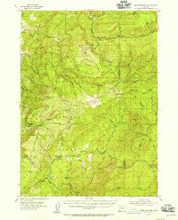
~ Bone Mountain OR topo map, 1:62500 scale, 15 X 15 Minute, Historical, 1954, updated 1955
Bone Mountain, Oregon, USGS topographic map dated 1954.
Includes geographic coordinates (latitude and longitude). This topographic map is suitable for hiking, camping, and exploring, or framing it as a wall map.
Printed on-demand using high resolution imagery, on heavy weight and acid free paper, or alternatively on a variety of synthetic materials.
Topos available on paper, Waterproof, Poly, or Tyvek. Usually shipping rolled, unless combined with other folded maps in one order.
- Product Number: USGS-5544278
- Free digital map download (high-resolution, GeoPDF): Bone Mountain, Oregon (file size: 11 MB)
- Map Size: please refer to the dimensions of the GeoPDF map above
- Weight (paper map): ca. 55 grams
- Map Type: POD USGS Topographic Map
- Map Series: HTMC
- Map Verison: Historical
- Cell ID: 51621
- Scan ID: 282265
- Imprint Year: 1955
- Woodland Tint: Yes
- Aerial Photo Year: 1952
- Field Check Year: 1954
- Datum: NAD27
- Map Projection: Polyconic
- Map published by United States Geological Survey
- Map Language: English
- Scanner Resolution: 600 dpi
- Map Cell Name: Bone Mountain
- Grid size: 15 X 15 Minute
- Date on map: 1954
- Map Scale: 1:62500
- Geographical region: Oregon, United States
Neighboring Maps:
All neighboring USGS topo maps are available for sale online at a variety of scales.
Spatial coverage:
Topo map Bone Mountain, Oregon, covers the geographical area associated the following places:
- Jenkins Prairie - Elk Horn Creek - Big Prairie - Arrastra Fork Mule Creek - Gobblers Knob - Bone Mountain - Ashur Flat - Gold Mountain - Diamond Peak - Fuller Creek - Rasler Creek - Bear Creek - Lockhart Recreation Site - Mount Bolivar - East Fork of West Fork Cow Creek - Lake Creek - Doe Swamp - Camp Hope - Panther Creek - Porphyry Spring - Buck Creek Campground - Coal Creek Camp - Barker Creek - Grant Creek - Fuller Mine - Clear Creek - Ketchin Butte - Fox Pond - Slide Creek - Panther Creek - August Knob - Lipp Creek - Slater Creek - Cawrses Log Pond - Wallace Creek - Cold Spring Camp - Foggy Creek Camp - Little Rock Creek - Cabin Creek - Elbow Point - Stanley Creek - Camp Number 2 - Wilson Creek - Sixmile Ridge - Bear Creek - Smith Creek - Bolivar Creek - Old Red Mine - Black Creek - Bear Creek Recreation Site - Upper Rock Creek - Anaktuvuk Saddle - Bolivar Spring - Mule Creek - Skull Ridge - Eden Valley - Gold Mountain Creek - Table Rock - Clear Creek Camp - Pheasant Creek - Pioneer Recreation Site - Ash Swamp - Kleiner Creek - Wooden Rock Guard Station - Cold Spring - Foggy Creek - Hidden Creek - Eden Valley Recreation Site - Walker Creek - Wooden Rock Creek - Wilson Head Quarry - Shields Creek - Fall Creek - Bone Mountain Pond - Eden Ridge - Buck Creek - Buck Point - Johnston Creek - Saddle Peaks - Bolivar Mine - North Creek - Long Prairie
- Map Area ID: AREA4342.75-124-123.75
- Northwest corner Lat/Long code: USGSNW43-124
- Northeast corner Lat/Long code: USGSNE43-123.75
- Southwest corner Lat/Long code: USGSSW42.75-124
- Southeast corner Lat/Long code: USGSSE42.75-123.75
- Northern map edge Latitude: 43
- Southern map edge Latitude: 42.75
- Western map edge Longitude: -124
- Eastern map edge Longitude: -123.75


