
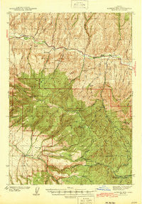
~ Aldrich Mtn OR topo map, 1:62500 scale, 15 X 15 Minute, Historical, 1943
Aldrich Mtn , Oregon, USGS topographic map dated 1943.
Includes geographic coordinates (latitude and longitude). This topographic map is suitable for hiking, camping, and exploring, or framing it as a wall map.
Printed on-demand using high resolution imagery, on heavy weight and acid free paper, or alternatively on a variety of synthetic materials.
Topos available on paper, Waterproof, Poly, or Tyvek. Usually shipping rolled, unless combined with other folded maps in one order.
- Product Number: USGS-5544192
- Free digital map download (high-resolution, GeoPDF): Aldrich Mtn , Oregon (file size: 11 MB)
- Map Size: please refer to the dimensions of the GeoPDF map above
- Weight (paper map): ca. 55 grams
- Map Type: POD USGS Topographic Map
- Map Series: HTMC
- Map Verison: Historical
- Cell ID: 50410
- Scan ID: 282218
- Woodland Tint: Yes
- Survey Year: 1940
- Datum: NAD27
- Map Projection: Polyconic
- Map published by United States Geological Survey
- Map Language: English
- Scanner Resolution: 600 dpi
- Map Cell Name: Aldrich Mountain
- Grid size: 15 X 15 Minute
- Date on map: 1943
- Map Scale: 1:62500
- Geographical region: Oregon, United States
Neighboring Maps:
All neighboring USGS topo maps are available for sale online at a variety of scales.
Spatial coverage:
Topo map Aldrich Mtn , Oregon, covers the geographical area associated the following places:
- Cummings Creek - Lemon Cabin - Stewart Cabin - Widows Creek - Mud Spring - China Hat Spring - Oregon Mine Camp - Glascock Ranch - Dry Creek Butte - Last Camp - Moores Crossing - Hattie Spring - Big Ridge - Aldrich Creek - Left Fork Scotty Creek - Little Bridge Creek - West Fork Warrens Creek - Fields Peak - Schoolhouse Gulch - Dry Cabin Creek Trail - Separation Corrals Camp - Dry Duncan Creek - Thorn Creek Butte - Todd Creek Camp - Hells Canyon Creek - Flat Creek - Fields Creek - Warrens Creek - Tex Creek - Timber Mountain - Pinchot Lake - Aldrich Mountain - Big Canyon - Goen Creek - Billy Fields Recreation Site - Stockdale Creek - Horseshoe Butte - Roosevelt Lake - Big Weasel Springs - Aldrich Mountains - Oregon Mine Creek - John Day Division - Dustin Creek - Beaver Creek - Todd Creek - Chrome Ridge - Cabbage Patch Spring - Cabin Creek - Bridge Creek - Deer Gulch - Last Creek - Water Gulch - Corral Gulch - Stewart Ditch - Dry Duncan Creek Trail - Dry Cabin Creek - Widows Creek Burn - Lick Spring - Grouse Creek - Dans Creek - Eddington Ditch - Dry Creek - Big Spring - Bark Cabin Creek - Cabbage Patch Camp - Picnic Creek - West Dry Creek - Murderers Creek Ranch - Tex Creek Arch - Thorn Creek - Buck Cabin Trail - Big Canyon Spring - Lick Spring - Tennessee Creek - East Fork Warrens Creek - Crazy Creek - Scotty Creek - Dry Gulch - Mountain View School (historical) - Orange Creek - Hattie Creek - Shaw Spring - Lemon Creek - No Name Creek - Stewart Lake - Oregon Mine - Wylie Gulch - Magpie Creek - Horse Creek - Buck Cabin - Murray Creek - Spring Gulch - Cow Canyon - Trail Ridge - Roaring Spring - Cabin Creek Trail - Cold Spring - Oregon Mine Recreation Site - Coyote Butte - Weaver Cabin
- Map Area ID: AREA44.544.25-119.5-119.25
- Northwest corner Lat/Long code: USGSNW44.5-119.5
- Northeast corner Lat/Long code: USGSNE44.5-119.25
- Southwest corner Lat/Long code: USGSSW44.25-119.5
- Southeast corner Lat/Long code: USGSSE44.25-119.25
- Northern map edge Latitude: 44.5
- Southern map edge Latitude: 44.25
- Western map edge Longitude: -119.5
- Eastern map edge Longitude: -119.25


