
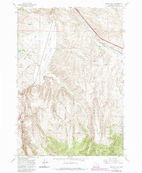
~ Bowen Valley OR topo map, 1:24000 scale, 7.5 X 7.5 Minute, Historical, 1967, updated 1985
Bowen Valley, Oregon, USGS topographic map dated 1967.
Includes geographic coordinates (latitude and longitude). This topographic map is suitable for hiking, camping, and exploring, or framing it as a wall map.
Printed on-demand using high resolution imagery, on heavy weight and acid free paper, or alternatively on a variety of synthetic materials.
Topos available on paper, Waterproof, Poly, or Tyvek. Usually shipping rolled, unless combined with other folded maps in one order.
- Product Number: USGS-5416896
- Free digital map download (high-resolution, GeoPDF): Bowen Valley, Oregon (file size: 15 MB)
- Map Size: please refer to the dimensions of the GeoPDF map above
- Weight (paper map): ca. 55 grams
- Map Type: POD USGS Topographic Map
- Map Series: HTMC
- Map Verison: Historical
- Cell ID: 5051
- Scan ID: 279110
- Imprint Year: 1985
- Woodland Tint: Yes
- Photo Revision Year: 1984
- Aerial Photo Year: 1981
- Edit Year: 1984
- Field Check Year: 1967
- Datum: NAD27
- Map Projection: Polyconic
- Map published by United States Geological Survey
- Map Language: English
- Scanner Resolution: 600 dpi
- Map Cell Name: Bowen Valley
- Grid size: 7.5 X 7.5 Minute
- Date on map: 1967
- Map Scale: 1:24000
- Geographical region: Oregon, United States
Neighboring Maps:
All neighboring USGS topo maps are available for sale online at a variety of scales.
Spatial coverage:
Topo map Bowen Valley, Oregon, covers the geographical area associated the following places:
- Shaffner Creek - Elk Creek - Salisbury Post Office (historical) - Nault Reservoir - Waldo Spring - Beaver Creek - West Fork Sutton Creek - Salisbury (historical) - Stices Gulch - Shaw Stewart Ditch - Sutton (historical) - Timber Gulch - Griffin Gulch - Currey Spring - Bowen Valley - S V Reservoir - Spring Creek Gulch - Stewart School (historical) - Prowell Reservoir - Blue Canyon - Bennehoff Reservoir - Belgian Gulch - Licklider Reservoir - Waldo Gulch - Trail Creek - West Beaver Creek - Vaughn Reservoir - Vaughn Dam - Juniper Gulch - Smith Ditch - Ebell Creek - Bowen (historical) - Quartz - Licklider Dam - South Baker (historical) - Baker City Sanitary Landfill
- Map Area ID: AREA44.7544.625-117.875-117.75
- Northwest corner Lat/Long code: USGSNW44.75-117.875
- Northeast corner Lat/Long code: USGSNE44.75-117.75
- Southwest corner Lat/Long code: USGSSW44.625-117.875
- Southeast corner Lat/Long code: USGSSE44.625-117.75
- Northern map edge Latitude: 44.75
- Southern map edge Latitude: 44.625
- Western map edge Longitude: -117.875
- Eastern map edge Longitude: -117.75


