
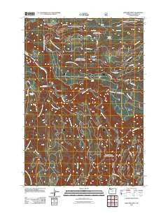
~ Bedford Point OR topo map, 1:24000 scale, 7.5 X 7.5 Minute, Historical, 2011
Bedford Point, Oregon, USGS topographic map dated 2011.
Includes geographic coordinates (latitude and longitude). This topographic map is suitable for hiking, camping, and exploring, or framing it as a wall map.
Printed on-demand using high resolution imagery, on heavy weight and acid free paper, or alternatively on a variety of synthetic materials.
Topos available on paper, Waterproof, Poly, or Tyvek. Usually shipping rolled, unless combined with other folded maps in one order.
- Product Number: USGS-5295086
- Free digital map download (high-resolution, GeoPDF): Bedford Point, Oregon (file size: 29 MB)
- Map Size: please refer to the dimensions of the GeoPDF map above
- Weight (paper map): ca. 55 grams
- Map Type: POD USGS Topographic Map
- Map Series: US Topo
- Map Verison: Historical
- Cell ID: 3009
- Datum: North American Datum of 1983
- Map Projection: Transverse Mercator
- Map Cell Name: Bedford Point
- Grid size: 7.5 X 7.5 Minute
- Date on map: 2011
- Map Scale: 1:24000
- Geographical region: Oregon, United States
Neighboring Maps:
All neighboring USGS topo maps are available for sale online at a variety of scales.
Spatial coverage:
Topo map Bedford Point, Oregon, covers the geographical area associated the following places:
- North Fork Crossing Forest Camp - Lazy Bend Quarry - Bedford Point Lookout - Dry Creek - Memaloose - Murphy Creek - Bee Creek - Lockaby Recreation Site - Fish Creek Recreation Site - Pup Creek Pit - Moore Creek - Small Fry Lake - Oregon City Water Patrol Station - Fall Creek - Torch Quarry - Helion Creek - Oz Pit - Lazy Bend Recreation Site - South Fork Clackamas River - Hillockburn Spring - Portland General Electric Promontory Park Boat Ramp - North Fork Guard Station - Bowyer Quarry - Cold Spring - Whisky Creek - South Fork Water Board Intake - Rimrock Creek - Winslow Creek - Mongrel Ridge Quarry - Mongrel Ridge - Bedford Creek - Helion Quarry - Armstrong Recreation Site - Oscar Creek - Memaloose Trail - Cultus Creek - Wanderers Peak Trail - La Dee Flat - Carter Bridge Recreation Site - Portland General Electric Promontory Park Marina - Memaloose Creek - Dog Creek - Bedford Point - Clackamas County - Fish Creek - Boyer Creek - Hesperin Camp - Carter Bridge Gravel Pit - Big Eddy Recreation Site - Big Cliff
- Map Area ID: AREA45.2545.125-122.25-122.125
- Northwest corner Lat/Long code: USGSNW45.25-122.25
- Northeast corner Lat/Long code: USGSNE45.25-122.125
- Southwest corner Lat/Long code: USGSSW45.125-122.25
- Southeast corner Lat/Long code: USGSSE45.125-122.125
- Northern map edge Latitude: 45.25
- Southern map edge Latitude: 45.125
- Western map edge Longitude: -122.25
- Eastern map edge Longitude: -122.125


