
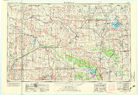
~ Woodward OK topo map, 1:250000 scale, 1 X 2 Degree, Historical, 1955, updated 1973
Woodward, Oklahoma, USGS topographic map dated 1955.
Includes geographic coordinates (latitude and longitude). This topographic map is suitable for hiking, camping, and exploring, or framing it as a wall map.
Printed on-demand using high resolution imagery, on heavy weight and acid free paper, or alternatively on a variety of synthetic materials.
Topos available on paper, Waterproof, Poly, or Tyvek. Usually shipping rolled, unless combined with other folded maps in one order.
- Product Number: USGS-5473205
- Free digital map download (high-resolution, GeoPDF): Woodward, Oklahoma (file size: 14 MB)
- Map Size: please refer to the dimensions of the GeoPDF map above
- Weight (paper map): ca. 55 grams
- Map Type: POD USGS Topographic Map
- Map Series: HTMC
- Map Verison: Historical
- Cell ID: 69110
- Scan ID: 802465
- Imprint Year: 1973
- Woodland Tint: Yes
- Visual Version Number: 2
- Aerial Photo Year: 1968
- Edit Year: 1971
- Field Check Year: 1955
- Datum: Unstated
- Map Projection: Transverse Mercator
- Map published by United States Geological Survey
- Map Language: English
- Scanner Resolution: 508 dpi
- Map Cell Name: Woodward
- Grid size: 1 X 2 Degree
- Date on map: 1955
- Map Scale: 1:250000
- Geographical region: Oklahoma, United States
Neighboring Maps:
All neighboring USGS topo maps are available for sale online at a variety of scales.
Spatial coverage:
Topo map Woodward, Oklahoma, covers the geographical area associated the following places:
- Brink - Alva - Fairview - Keenan - Cherokee - Fort Supply - Plainview - Driftwood - Nescatunga - Lahoma - Gage - Mooreland - Goodwin - Ringwood - Orienta - Carrier - Parvin - Sand Creek - Lindley - Curtis - Lenora - Cedardale - Darrow - Cleo Springs - Waynoka - Fargo - Okeene - Fonda - McWillie - Seiling - Lacey - Meno - Nash - Shattuck - Tegarden - Manchester - Helena - Orion - Ingersoll - Willard - Carwile - Carleton - Ashley - Quinlan - Bado - Cora - May - Harmon - Bouse Junction - Cato - Piper - Alston - Woodward - Togo - Rosston - Taloga - Hawley - Carmen - Hucmac - Winchester - Goltry - Vici - Canton - Ames - Sharon - Isabella - Dacoma - Lambert - Gerlach - Buffalo - Fairvalley - Tangier - Touzalin - Camargo - Drummond - Hopeton - Freedom - Carlton - Southard - Longdale - Laverne - Catesby - Cedar Springs - West Cleo - Cestos - Avard - Mutual - Vining - Amorita - Dane - Belva - Dunlap - Barr - Yewed - Heman - Noel - Phroso - Crystal Lakes - Charleston (historical) - Capron
- Map Area ID: AREA3736-100-98
- Northwest corner Lat/Long code: USGSNW37-100
- Northeast corner Lat/Long code: USGSNE37-98
- Southwest corner Lat/Long code: USGSSW36-100
- Southeast corner Lat/Long code: USGSSE36-98
- Northern map edge Latitude: 37
- Southern map edge Latitude: 36
- Western map edge Longitude: -100
- Eastern map edge Longitude: -98


