
~ Ardmore OK topo map, 1:250000 scale, 1 X 2 Degree, Historical, 1957, updated 1968
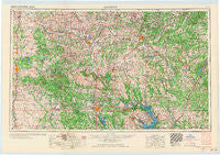
Ardmore, Oklahoma, USGS topographic map dated 1957.
Includes geographic coordinates (latitude and longitude). This topographic map is suitable for hiking, camping, and exploring, or framing it as a wall map.
Printed on-demand using high resolution imagery, on heavy weight and acid free paper, or alternatively on a variety of synthetic materials.
Topos available on paper, Waterproof, Poly, or Tyvek. Usually shipping rolled, unless combined with other folded maps in one order.
- Product Number: USGS-5473145
- Free digital map download (high-resolution, GeoPDF): Ardmore, Oklahoma (file size: 15 MB)
- Map Size: please refer to the dimensions of the GeoPDF map above
- Weight (paper map): ca. 55 grams
- Map Type: POD USGS Topographic Map
- Map Series: HTMC
- Map Verison: Historical
- Cell ID: 68649
- Scan ID: 800771
- Imprint Year: 1968
- Woodland Tint: Yes
- Edit Year: 1967
- Datum: Unstated
- Map Projection: Transverse Mercator
- Map published by United States Geological Survey
- Map Language: English
- Scanner Resolution: 508 dpi
- Map Cell Name: Ardmore
- Grid size: 1 X 2 Degree
- Date on map: 1957
- Map Scale: 1:250000
- Geographical region: Oklahoma, United States
Neighboring Maps:
All neighboring USGS topo maps are available for sale online at a variety of scales.
Spatial coverage:
Topo map Ardmore, Oklahoma, covers the geographical area associated the following places:
- Ury - Vanoss - Chigley - Sunray - Wallville - Pritchard - Sugden - Cottonwood - Stringtown - Union Hill - Matoy - Sevenmile Corner - Connerville - Newport - Wynnewood - Dripping Springs - Johnsonville - Olney - Gene Autry - Dixie Park - Alpers - Caney - Stonewall - Rosedale - Tishomingo - Wayne - Asher - Franks - Tupelo - Eville - Erin Springs - Scullin - Hoxbar - Jesse - Pontotoc - Pike City (historical) - Healdton - Wapanucka - Comanche - Post Oak - Dolberg (historical) - Orr - Hope - Kenefic - Linn - McGee - Woodford - Whitebead - Denny - Reck (historical) - Davis - Stuart - Oswalt - Marlow - Banty - Bokchito - Meridian - Greenville - Konawa - Earl - Russett - Maxwell - Duncan - Byng - Oil City - Calvin - Emet - Lindsay - Dundee - Liberty - Bee - Mannsville - Stratford - Aylesworth - Wirt - Robinson Corner - Marsden - Atoka - Citra - Asphaltum - Ringling - Hopewell - Ratliff City - Neill - Joy - Criner - Hickory - Jollyville - Clemscott - Crusher - Bennington - Addington - Brady - Fillmore - Baum - Marlow - Cheek - Lehigh - Ward Springs - Ninnekah
- Map Area ID: AREA3534-98-96
- Northwest corner Lat/Long code: USGSNW35-98
- Northeast corner Lat/Long code: USGSNE35-96
- Southwest corner Lat/Long code: USGSSW34-98
- Southeast corner Lat/Long code: USGSSE34-96
- Northern map edge Latitude: 35
- Southern map edge Latitude: 34
- Western map edge Longitude: -98
- Eastern map edge Longitude: -96


