
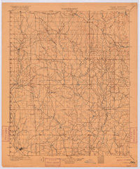
~ Addington OK topo map, 1:125000 scale, 30 X 30 Minute, Historical, 1901, updated 1916
Addington, Oklahoma, USGS topographic map dated 1901.
Includes geographic coordinates (latitude and longitude). This topographic map is suitable for hiking, camping, and exploring, or framing it as a wall map.
Printed on-demand using high resolution imagery, on heavy weight and acid free paper, or alternatively on a variety of synthetic materials.
Topos available on paper, Waterproof, Poly, or Tyvek. Usually shipping rolled, unless combined with other folded maps in one order.
- Product Number: USGS-5468429
- Free digital map download (high-resolution, GeoPDF): Addington, Oklahoma (file size: 5 MB)
- Map Size: please refer to the dimensions of the GeoPDF map above
- Weight (paper map): ca. 55 grams
- Map Type: POD USGS Topographic Map
- Map Series: HTMC
- Map Verison: Historical
- Cell ID: 64851
- Scan ID: 802471
- Imprint Year: 1916
- Survey Year: 1898
- Datum: Unstated
- Map Projection: Unstated
- Map published by United States Geological Survey
- Map Language: English
- Scanner Resolution: 508 dpi
- Map Cell Name: Addington
- Grid size: 30 X 30 Minute
- Date on map: 1901
- Map Scale: 1:125000
- Geographical region: Oklahoma, United States
Neighboring Maps:
All neighboring USGS topo maps are available for sale online at a variety of scales.
Spatial coverage:
Topo map Addington, Oklahoma, covers the geographical area associated the following places:
- Sunray - Harrisburg - Grady - Sugden - Pruitt City - Alma - Cornish - Cobalt Junction - Liberty - Meridian - Wirt - Velma - Ryan - Ratliff City - Orr - Atlee - Addington - Comanche - Santa Fe - Pike City (historical) - Loco - Dundee - Oklahoma Hills - Waurika - Ringling - Countyline - Asphaltum - Dixie Park
- Map Area ID: AREA34.534-98-97.5
- Northwest corner Lat/Long code: USGSNW34.5-98
- Northeast corner Lat/Long code: USGSNE34.5-97.5
- Southwest corner Lat/Long code: USGSSW34-98
- Southeast corner Lat/Long code: USGSSE34-97.5
- Northern map edge Latitude: 34.5
- Southern map edge Latitude: 34
- Western map edge Longitude: -98
- Eastern map edge Longitude: -97.5


