
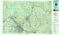
~ Youngstown OH topo map, 1:100000 scale, 30 X 60 Minute, Historical, 1986, updated 1989
Youngstown, Ohio, USGS topographic map dated 1986.
Includes geographic coordinates (latitude and longitude). This topographic map is suitable for hiking, camping, and exploring, or framing it as a wall map.
Printed on-demand using high resolution imagery, on heavy weight and acid free paper, or alternatively on a variety of synthetic materials.
Topos available on paper, Waterproof, Poly, or Tyvek. Usually shipping rolled, unless combined with other folded maps in one order.
- Product Number: USGS-5332016
- Free digital map download (high-resolution, GeoPDF): Youngstown, Ohio (file size: 26 MB)
- Map Size: please refer to the dimensions of the GeoPDF map above
- Weight (paper map): ca. 55 grams
- Map Type: POD USGS Topographic Map
- Map Series: HTMC
- Map Verison: Historical
- Cell ID: 68628
- Scan ID: 223705
- Imprint Year: 1989
- Woodland Tint: Yes
- Aerial Photo Year: 1983
- Edit Year: 1986
- Datum: NAD27
- Map Projection: Universal Transverse Mercator
- Map published by United States Geological Survey
- Map Language: English
- Scanner Resolution: 600 dpi
- Map Cell Name: Youngstown
- Grid size: 30 X 60 Minute
- Date on map: 1986
- Map Scale: 1:100000
- Geographical region: Ohio, United States
Neighboring Maps:
All neighboring USGS topo maps are available for sale online at a variety of scales.
Spatial coverage:
Topo map Youngstown, Ohio, covers the geographical area associated the following places:
- McCoytown - New Virginia - Rosemont - McKinley Heights - Grimms Mobile Home Park - Hermitage - Petroleum - Rose Park - Henlein - Minnis Corner - New Bedford - King Corners - DeForest Junction - Lynns Corners - Maysville - Masury - King's Mobile Home Park - Milledgeville - Coaltown - Redmond - Keisters - Five Points - Jamestown - New Lebanon - Gustavus - Schollard - Clover Hill - Nashua - Cottage Grove - Fourmile Run - Millburn - Dutch Hill - State Road - Mineral Ridge - Churchill - Elliotts Mills - Five Points - Perrys Corners - Loys Corners - Spokane - Farmington - Central Mobile Home Park - Clark - Flint Hill - McCoys Corners - Geography Hall - Craig Beach - Shenango - Oakfield - Ekerts Corners - Courtneys Mills - Austin Village - South Niles - Salem - Tyrrell - Parkstown - Robinson - Brentwood Mobile Home Park - Maderite Heights - Shady Lane Mobile Home Park - Clarks Mills - Rices Mills - Girard - Fairview - Fosterville - Cortland - North Side - Wilhelm Corner - Rockville - Carbon - Hartford - Farmdale - Arhaven Estates - Corinth - Kenilworth - Osgood - Brookfield Center - Walmo - Lakeview Mobile Home Park - Leesburg - Millbrook - Harbor - Superior (historical) - DeForest - Forest Grove Mobile Home Park - Madden Corners - Greencrest Park - Crab Creek Junction - Kremis - Villa Maria - Orangeville - Doughton (historical) - Walnut Hill (historical) - Trumbull Homes - Slippery Rock - Hendersonville - Herner Corners - New Hamburg - North Edinburg - Belmar Park
- Map Area ID: AREA41.541-81-80
- Northwest corner Lat/Long code: USGSNW41.5-81
- Northeast corner Lat/Long code: USGSNE41.5-80
- Southwest corner Lat/Long code: USGSSW41-81
- Southeast corner Lat/Long code: USGSSE41-80
- Northern map edge Latitude: 41.5
- Southern map edge Latitude: 41
- Western map edge Longitude: -81
- Eastern map edge Longitude: -80


