
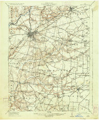
~ Xenia OH topo map, 1:62500 scale, 15 X 15 Minute, Historical, 1917, updated 1934
Xenia, Ohio, USGS topographic map dated 1917.
Includes geographic coordinates (latitude and longitude). This topographic map is suitable for hiking, camping, and exploring, or framing it as a wall map.
Printed on-demand using high resolution imagery, on heavy weight and acid free paper, or alternatively on a variety of synthetic materials.
Topos available on paper, Waterproof, Poly, or Tyvek. Usually shipping rolled, unless combined with other folded maps in one order.
- Product Number: USGS-5321438
- Free digital map download (high-resolution, GeoPDF): Xenia, Ohio (file size: 6 MB)
- Map Size: please refer to the dimensions of the GeoPDF map above
- Weight (paper map): ca. 55 grams
- Map Type: POD USGS Topographic Map
- Map Series: HTMC
- Map Verison: Historical
- Cell ID: 64744
- Scan ID: 226445
- Imprint Year: 1934
- Survey Year: 1914
- Datum: NAD
- Map Projection: Polyconic
- Map published by United States Geological Survey
- Map Language: English
- Scanner Resolution: 600 dpi
- Map Cell Name: Xenia
- Grid size: 15 X 15 Minute
- Date on map: 1917
- Map Scale: 1:62500
- Geographical region: Ohio, United States
Neighboring Maps:
All neighboring USGS topo maps are available for sale online at a variety of scales.
Spatial coverage:
Topo map Xenia, Ohio, covers the geographical area associated the following places:
- Silver Springs - Monroe - Gurneyville - Maple Corner - Shawnee Hills - Gunnerville - New Jasper - Ogles (historical) - North Kingman - Wilberforce - New Burlington - Cedarville - Oldtown - Pattersons Corner - Paintersville - Bryson (historical) - Waynetta Mobile Home Park - Xenia - Middleton Corner - Port William - Pinewood Village - Lumberton - Stringtown - McKays - Mount Pleasant - Kingman - Trebein - Cornstalk
- Map Area ID: AREA39.7539.5-84-83.75
- Northwest corner Lat/Long code: USGSNW39.75-84
- Northeast corner Lat/Long code: USGSNE39.75-83.75
- Southwest corner Lat/Long code: USGSSW39.5-84
- Southeast corner Lat/Long code: USGSSE39.5-83.75
- Northern map edge Latitude: 39.75
- Southern map edge Latitude: 39.5
- Western map edge Longitude: -84
- Eastern map edge Longitude: -83.75


