
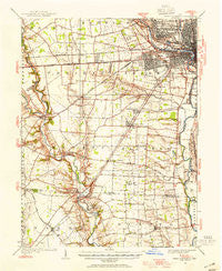
~ West Columbus OH topo map, 1:62500 scale, 15 X 15 Minute, Historical, 1923, updated 1955
West Columbus, Ohio, USGS topographic map dated 1923.
Includes geographic coordinates (latitude and longitude). This topographic map is suitable for hiking, camping, and exploring, or framing it as a wall map.
Printed on-demand using high resolution imagery, on heavy weight and acid free paper, or alternatively on a variety of synthetic materials.
Topos available on paper, Waterproof, Poly, or Tyvek. Usually shipping rolled, unless combined with other folded maps in one order.
- Product Number: USGS-5321408
- Free digital map download (high-resolution, GeoPDF): West Columbus, Ohio (file size: 7 MB)
- Map Size: please refer to the dimensions of the GeoPDF map above
- Weight (paper map): ca. 55 grams
- Map Type: POD USGS Topographic Map
- Map Series: HTMC
- Map Verison: Historical
- Cell ID: 64405
- Scan ID: 226559
- Imprint Year: 1955
- Woodland Tint: Yes
- Survey Year: 1923
- Datum: NAD27
- Map Projection: Polyconic
- Map published by United States Geological Survey
- Map Language: English
- Scanner Resolution: 600 dpi
- Map Cell Name: West Columbus
- Grid size: 15 X 15 Minute
- Date on map: 1923
- Map Scale: 1:62500
- Geographical region: Ohio, United States
Neighboring Maps:
All neighboring USGS topo maps are available for sale online at a variety of scales.
Spatial coverage:
Topo map West Columbus, Ohio, covers the geographical area associated the following places:
- Creekside - Chestnut Farms - Quail Creek - San Margherita - Valley View - Meadow Grove Estates - Elginfield - Rush Creek - New Rome - Park Ridge - Tanglebrook - Lincoln Village - Alkire Place - The Crossing At Grants Run - Westchester - Zuber (historical) - Alkire Woods - Hennigans Grove - Sweetwater - Parlin Manor - Matville - Meadow Grove South - Alkire Lakes - La Rosa - Ridpath (historical) - Meadow Grove East - Briarwood Hills - Clifton Chase - Great Oak - Oak Grove - Urbancrest - Concord Lakes - Briggsdale - Shadeville - Deems (historical) - Glenchester - Hoover Park - Robroy Estates - Scioto Meadows - Greene Countrie - Mayfair Park - Oakmont Village - Summerlyn - Hidden Meadows - Parkside Village - Grandview Heights - Haughn Glen - Hawthorne Woods - Pine Manor - Claybrooke Crossings - Pine Grove - Farmbrook - Marble Cliff - The Meadows - Wrightville - Grove City Heights - Rome - Keller Farm East - Upper Arlington - Woodfield Oaks - Edgewater - Grove City - Highland Park - Sullivants (historical) - Landings At Quail Creek - Grove City Country Club - Holton Run - Georgesville - Willows At Quail Creek - Post Oak Country Estates - Village At Scioto Meadows - Thornapple Grove - Alkire Village - Kingswood Heights - Galloway - Meadow Grove - West Grove - High Meadow - Brookgrove - Jackson Homes - Keller Farm - Timberbrook - Ravines At Quail Creek - The Village At Thornapple - Autumn Grove - Heritage Glen - Brook Park - Village Park - Darbydale - Halloway - Castle Farms - Parkside Estates - Hilliard Green - Alton - Barfield Heights - Millers (historical) - Walden Bluffs - Wagon Wheel Mobile Home Park - Ledgestone At Indian Trails - Sherry Lynne Homes
- Map Area ID: AREA4039.75-83.25-83
- Northwest corner Lat/Long code: USGSNW40-83.25
- Northeast corner Lat/Long code: USGSNE40-83
- Southwest corner Lat/Long code: USGSSW39.75-83.25
- Southeast corner Lat/Long code: USGSSE39.75-83
- Northern map edge Latitude: 40
- Southern map edge Latitude: 39.75
- Western map edge Longitude: -83.25
- Eastern map edge Longitude: -83


