
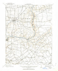
~ Morrow OH topo map, 1:62500 scale, 15 X 15 Minute, Historical, 1914, updated 1963
Morrow, Ohio, USGS topographic map dated 1914.
Includes geographic coordinates (latitude and longitude). This topographic map is suitable for hiking, camping, and exploring, or framing it as a wall map.
Printed on-demand using high resolution imagery, on heavy weight and acid free paper, or alternatively on a variety of synthetic materials.
Topos available on paper, Waterproof, Poly, or Tyvek. Usually shipping rolled, unless combined with other folded maps in one order.
- Product Number: USGS-5321118
- Free digital map download (high-resolution, GeoPDF): Morrow, Ohio (file size: 6 MB)
- Map Size: please refer to the dimensions of the GeoPDF map above
- Weight (paper map): ca. 55 grams
- Map Type: POD USGS Topographic Map
- Map Series: HTMC
- Map Verison: Historical
- Cell ID: 57906
- Scan ID: 227943
- Imprint Year: 1963
- Survey Year: 1914
- Datum: NAD27
- Map Projection: Polyconic
- Map published by United States Geological Survey
- Map Language: English
- Scanner Resolution: 600 dpi
- Map Cell Name: Morrow
- Grid size: 15 X 15 Minute
- Date on map: 1914
- Map Scale: 1:62500
- Geographical region: Ohio, United States
Neighboring Maps:
All neighboring USGS topo maps are available for sale online at a variety of scales.
Spatial coverage:
Topo map Morrow, Ohio, covers the geographical area associated the following places:
- Pleasant Plain - Roachester - Mathers Mills - Ridge (historical) - Dodds - Lelan (historical) - Kings Mills - Dallasburg - San Je Village - Hicks - Osceola - Lebanon - Hopkinsville - Avalon Heights - Rossburg - Woodville - Morrow - Hills - Oregonia - Wellman - Usrey Mobile Home Park - Poe's Trailer Park - Edwardsville - Genntown - Windsor - Comargo - Middleboro - Red Lion - South Lebanon - Blackhawk - Mary Ellen - Cozaddale - Senior - Maineville - Zoar - Murdock - Butlerville - Merrittstown - Utica
- Map Area ID: AREA39.539.25-84.25-84
- Northwest corner Lat/Long code: USGSNW39.5-84.25
- Northeast corner Lat/Long code: USGSNE39.5-84
- Southwest corner Lat/Long code: USGSSW39.25-84.25
- Southeast corner Lat/Long code: USGSSE39.25-84
- Northern map edge Latitude: 39.5
- Southern map edge Latitude: 39.25
- Western map edge Longitude: -84.25
- Eastern map edge Longitude: -84


