
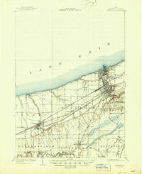
~ Ashtabula OH topo map, 1:62500 scale, 15 X 15 Minute, Historical, 1905, updated 1945
Ashtabula, Ohio, USGS topographic map dated 1905.
Includes geographic coordinates (latitude and longitude). This topographic map is suitable for hiking, camping, and exploring, or framing it as a wall map.
Printed on-demand using high resolution imagery, on heavy weight and acid free paper, or alternatively on a variety of synthetic materials.
Topos available on paper, Waterproof, Poly, or Tyvek. Usually shipping rolled, unless combined with other folded maps in one order.
- Product Number: USGS-5320640
- Free digital map download (high-resolution, GeoPDF): Ashtabula, Ohio (file size: 5 MB)
- Map Size: please refer to the dimensions of the GeoPDF map above
- Weight (paper map): ca. 55 grams
- Map Type: POD USGS Topographic Map
- Map Series: HTMC
- Map Verison: Historical
- Cell ID: 50733
- Scan ID: 224816
- Imprint Year: 1945
- Survey Year: 1903
- Datum: NAD
- Map Projection: Polyconic
- Map published by United States Geological Survey
- Map Language: English
- Scanner Resolution: 600 dpi
- Map Cell Name: Ashtabula
- Grid size: 15 X 15 Minute
- Date on map: 1905
- Map Scale: 1:62500
- Geographical region: Ohio, United States
Neighboring Maps:
All neighboring USGS topo maps are available for sale online at a variety of scales.
Spatial coverage:
Topo map Ashtabula, Ohio, covers the geographical area associated the following places:
- Saybrook - Woodman Mobile Home Park - Avondale - Elks View - Plymouth Center - Normandy Village Mobile Home Park - Meadowood - Highland Beach - East Ashtabula - Harbor - Geneva-on-the-Lake - Mechanicsville - Buckeye Beach - Austinburg - Palmetto Beach - Edgewood - Erieview - Oakwood Mobile Home Park - Munson Hill - Harpersfield - Grandview Park - Elmwood - Crestlawn Village - A C Mobile Home Park - Keyes Trailer Park - Chapel - Woodmere - Jefferson Mobile Estates - Century Bay - Profeta's Mobile Home Park - Holdlen Hills - Whispering Willows Mobile Home Park - Ashtabula - Lakegrove Estates - Willow Arms - Saybrook-on-the-lake - Geneva - Mareddy Estates - Edgewood Trailer Park - State Road Mobile Home Park - Parkwood Village - Mapleton Beach
- Map Area ID: AREA4241.75-81-80.75
- Northwest corner Lat/Long code: USGSNW42-81
- Northeast corner Lat/Long code: USGSNE42-80.75
- Southwest corner Lat/Long code: USGSSW41.75-81
- Southeast corner Lat/Long code: USGSSE41.75-80.75
- Northern map edge Latitude: 42
- Southern map edge Latitude: 41.75
- Western map edge Longitude: -81
- Eastern map edge Longitude: -80.75


