
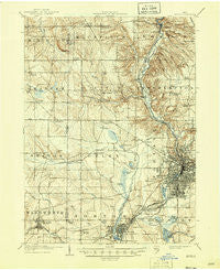
~ Akron OH topo map, 1:62500 scale, 15 X 15 Minute, Historical, 1905, updated 1946
Akron, Ohio, USGS topographic map dated 1905.
Includes geographic coordinates (latitude and longitude). This topographic map is suitable for hiking, camping, and exploring, or framing it as a wall map.
Printed on-demand using high resolution imagery, on heavy weight and acid free paper, or alternatively on a variety of synthetic materials.
Topos available on paper, Waterproof, Poly, or Tyvek. Usually shipping rolled, unless combined with other folded maps in one order.
- Product Number: USGS-5320598
- Free digital map download (high-resolution, GeoPDF): Akron, Ohio (file size: 8 MB)
- Map Size: please refer to the dimensions of the GeoPDF map above
- Weight (paper map): ca. 55 grams
- Map Type: POD USGS Topographic Map
- Map Series: HTMC
- Map Verison: Historical
- Cell ID: 50378
- Scan ID: 224711
- Imprint Year: 1946
- Survey Year: 1903
- Datum: Unstated
- Map Projection: Polyconic
- Map published by United States Geological Survey
- Map Language: English
- Scanner Resolution: 600 dpi
- Map Cell Name: Akron
- Grid size: 15 X 15 Minute
- Date on map: 1905
- Map Scale: 1:62500
- Geographical region: Ohio, United States
Neighboring Maps:
All neighboring USGS topo maps are available for sale online at a variety of scales.
Spatial coverage:
Topo map Akron, Ohio, covers the geographical area associated the following places:
- Shamrock Trailer Park - Cranmer - Indian Springs Mobile Home Park - Copley - Fairlawn - Kenmore - West Akron - Lakeside Mobile Park - Firestone Park - Granger - Sunset Mobile Home Park - Barberton - Maple Valley - Lawndale - Bath Center - Akron - Barberton Trailer Park (historical) - Bates Corners - Wadsworth Trailer Park - Pigeon Creek - Norton - Hinckley - Sherman (historical) - Bath - Halo - Richfield - Ira - East Steels Corners - Iron Bridge (historical) - Wadsworth - Sharon Center - Botzum - Oak Leaf Mobile Home Park - South Akron - Richfield Heights - Stoney Hill - M And C Mobile Village - Copley Junction - Ghent - Buzzard Roost - Clark Corners - Swartz Corners - New Portage - North Akron - Remsen Corners - Everett - Peninsula - Youngs Corners - Coddingville - Western Star - West Richfield - Broadview - Summit Beach Park - West Steels Corners - Northampton Center - Johnsons Corners - Portage Lakes - Montrose - Paxton - Nemes Trailer Park - Osborn Corners - Echo Lake Glen - Cascade (historical)
- Map Area ID: AREA41.2541-81.75-81.5
- Northwest corner Lat/Long code: USGSNW41.25-81.75
- Northeast corner Lat/Long code: USGSNE41.25-81.5
- Southwest corner Lat/Long code: USGSSW41-81.75
- Southeast corner Lat/Long code: USGSSE41-81.5
- Northern map edge Latitude: 41.25
- Southern map edge Latitude: 41
- Western map edge Longitude: -81.75
- Eastern map edge Longitude: -81.5


