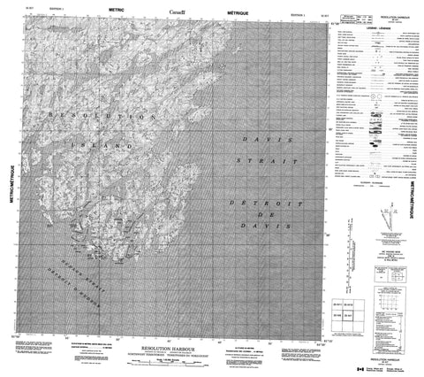
025H07 Resolution Harbour Canada topo map, 1:50,000 scale
025H07 Resolution Harbour NRCAN topographic map.
Includes UTM and GPS geographic coordinates (latitude and longitude). This 50k scale map is suitable for hiking, camping, and exploring, or you could frame it as a wall map.
Printed on-demand using high resolution, on heavy weight and acid free paper, or as an upgrade on a variety of synthetic materials.
Topos available on paper, Waterproof, Poly, or Tyvek. Usually shipping rolled, unless combined with other folded maps in one order.
- Product Number: NRCAN-025H07
- Parent Topo: TOPO-025H
- Map ID also known as: 025H07, 25H7, 25H07
- Unfolded Size: Approximately 26" high by 36" wide
- Weight (paper map): ca. 55 grams
- Map Type: POD NRCAN Topographic Map
- Map Scale: 1:50,000
- Geographical region: Nunavut, Canada
Neighboring Maps:
All neighboring Canadian topo maps are available for sale online at 1:50,000 scale.
Purchase the smaller scale map covering this area: Topo-025H
Spatial coverage:
Topo map sheet 025H07 Resolution Harbour covers the following places:
- Acadia Cove - Cook Bay - Resolution Harbour - Watering Cove - Beak Point - Hatton Headland - Topsail Head - White Head - Acadia Passage - Cook Passage - Danger Passage - Détroit d'Hudson - Foul Passage - Hudson Strait - Lanyard Passage - Resolution Tickle - Boatswain Island - Cockade Island - Dwarf Island - Entry Islands - Haven Island - Hen and Chicks - Mark Island - Mizzen Island - Radio Island - Resolution Island - Sentinel Island - Star Island - Stock Island - Trident Island - Tusk Island - Watt Islands - Sweetwater Lake - The Swirlers - Bilge Rocks - Puck Rock - Twin Rocks - Resolution Island