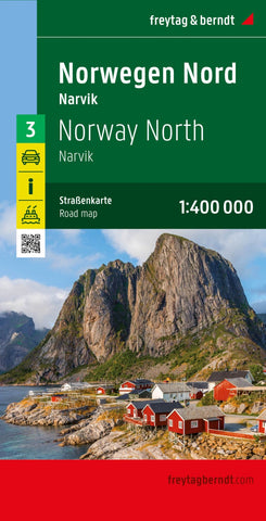
Norway North, road Map 1:400,000
One of the titles in a series of detailed, indexed touring maps with plenty of tourist information. Southern Norway is shown at 1:250,000, with the two northern sheets at 1:400,000. Relief shading with spot heights indicates the terrain, with forested areas and natural features such as glaciers clearly marked. Road network includes private roads, toll routes, restrictions and winter closures, steep gradients, motorway service areas and accommodation, scenic routes, and intermediate driving distances on most roads. Railway network with stations and ferry connections are also marked.
The maps also show large amount of tourist information: recreational facilities, places of interest, various types of accommodation, etc. Latitude and longitude grid is at intervals of 10’ on the two southern maps and 30 in northern Norway. A separate booklet attached to the map cover has an index of localities. Map legend includes English.
- Product Number: FB_NOR_3_24
- Reference Product Number: - None -
- ISBN: 9783707922127
- Date of Publication: 10/30/2023
- Folded Size: 10.02 inches high by 5.11 inches wide
- Unfolded (flat) Size: 10.02 inches high by 5.11 inches wide
- Map format: Folded
- Map type: Trade Maps - Road
- Geographical region: Norway