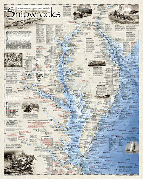
Shipwrecks of the Northeast, Folded Wall Map by National Geographic Maps
Developed by renowned marine archaeologist and accomplished author Don Shomette and designed by award-winning cartographer Robert Pratt, Shipwrecks of the Northeast is a stunning new map illustrating more than 5,400 known shipwrecks on the untamed Atlantic coast of New England (Maine, Massachusetts, New Hampshire and Rhode Island).
From Rhode Islands Narragansett Bay to Maines St. Croix River, the shipwrecks are clearly marked atop beautiful bathymetric and coastal detail. Each wreck site is symbolized to define the class, type, and name of vessel accompanied by the date of sinking. Icons also indicate whether a ship was lost due to conflict or natural causes.
Locations of lifesaving stations and lighthouses, along with navigational beacons are also marked. Bathymetric and coastal features are clearly labeled, accompanied by inset maps for Nantucket Sound, Cape Cod Bay, and Marthas Vineyard, Rhode Islands Narragansett Bay and the Boston Harbor Islands.
Captions and drawings are used to highlight unique historical events such as the infamous sinking of the Italian luxury liner Andrea Doria on July 25, 1956 when it collided with the M/V Stockholm in the fog off Nantucket. The first fully authenticated pirate ship, Whydah, is also highlighted in the Pirates of New England section of the map.
Wrecks featured on this map span from mid-1600s galleons to 20th-century naval ships, those lost in military conflict, foul weather, mutinies, unseen rocks, treacherous shoals, mechanical failures, and a myriad of other events. Whether a naval buff, educator, amateur historian, mariner, or someone simply enamored with the captivating power of the sea-Shipwrecks of the Northeast is a great gift and a perfect addition to your map collection.
- Product Number: 2186405M
- Product Code: NG_SHIP_NE
- Publisher Product ID: RE01020609
- ISBN: 9781597754316
- Year of Publication: 2011
- Folded Size: 9.06 x 7.09 inches
- Unfolded Size: 26.38 x 34.45 inches
- Map type: Folded Map
- Geographical region: Northeast USA