
~ Bismarck ND topo map, 1:250000 scale, 1 X 2 Degree, Historical, 1958, updated 1958
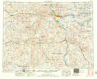
Bismarck, North Dakota, USGS topographic map dated 1958.
Includes geographic coordinates (latitude and longitude). This topographic map is suitable for hiking, camping, and exploring, or framing it as a wall map.
Printed on-demand using high resolution imagery, on heavy weight and acid free paper, or alternatively on a variety of synthetic materials.
Topos available on paper, Waterproof, Poly, or Tyvek. Usually shipping rolled, unless combined with other folded maps in one order.
- Product Number: USGS-5473729
- Free digital map download (high-resolution, GeoPDF): Bismarck, North Dakota (file size: 20 MB)
- Map Size: please refer to the dimensions of the GeoPDF map above
- Weight (paper map): ca. 55 grams
- Map Type: POD USGS Topographic Map
- Map Series: HTMC
- Map Verison: Historical
- Cell ID: 68678
- Scan ID: 285507
- Imprint Year: 1958
- Woodland Tint: Yes
- Aerial Photo Year: 1952
- Datum: Unstated
- Map Projection: Transverse Mercator
- Map published by United States Geological Survey
- Map published by United States Army Corps of Engineers
- Map published by United States Army
- Map Language: English
- Scanner Resolution: 600 dpi
- Map Cell Name: Bismarck
- Grid size: 1 X 2 Degree
- Date on map: 1958
- Map Scale: 1:250000
- Geographical region: North Dakota, United States
Neighboring Maps:
All neighboring USGS topo maps are available for sale online at a variety of scales.
Spatial coverage:
Topo map Bismarck, North Dakota, covers the geographical area associated the following places:
- Hazelton - On-a-Slant Village (historical) - Leith - El Rancho Mobile Home Park - Lynwood - New Leipzig - Wildwood Mobile Home Park - Breien - Cannon Ball - Almont - Linton - Eagle Nest - Hillcrest Acres - Schmidt - Solen - Sky Way Mobile Home Park - Bismarck - Fort Rice - Grassna - Double Ditch Indian Village - Saint Anthony - Arnold - Evas Mobile Home Court - Bluegrass - Elgin - Shields - Dana - Judson - Temvik - Apple Valley - Freda - Sunny - New Salem - North Valley Park - Menoken - Lark - Mandan - Johnson Ford - Harmon - Carson - Porcupine - Sims - Kens Mobile Home Park - Timmer - North Almont - Heil - Fallon - Dengate - Brittin - Westfield - Braddock - Hay Creek Court - Midway - Glen Ullin - McKenzie - Hull - Huff - Brisbane - Tatley Meadows - Parkview Estates - Sweet Briar - Lincoln - Raleigh - Pierce - Selfridge - Frontier Homesteads - Livona - Terrace Heights Mobile Home Park - Strasburg - Lyons - Chance Mobile Home Park - Rock Haven - Meadow Park - Sterling - Holiday Park - Twin City Estates - Chadwick - Stardust Terrace - Mister Bs Estates - Hi-loh Mobile Park - Wollman Ranch Colony - Driscoll - Colonial Estates - Saint Gertrude - Flasher - Fort Yates - Apple Creek Mobile Home Community - Youngtown - Moffit
- Map Area ID: AREA4746-102-100
- Northwest corner Lat/Long code: USGSNW47-102
- Northeast corner Lat/Long code: USGSNE47-100
- Southwest corner Lat/Long code: USGSSW46-102
- Southeast corner Lat/Long code: USGSSE46-100
- Northern map edge Latitude: 47
- Southern map edge Latitude: 46
- Western map edge Longitude: -102
- Eastern map edge Longitude: -100


