
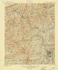
~ Asheville NC topo map, 1:125000 scale, 30 X 30 Minute, Historical, 1901, updated 1948
Asheville, North Carolina, USGS topographic map dated 1901.
Includes geographic coordinates (latitude and longitude). This topographic map is suitable for hiking, camping, and exploring, or framing it as a wall map.
Printed on-demand using high resolution imagery, on heavy weight and acid free paper, or alternatively on a variety of synthetic materials.
Topos available on paper, Waterproof, Poly, or Tyvek. Usually shipping rolled, unless combined with other folded maps in one order.
- Product Number: USGS-5374900
- Free digital map download (high-resolution, GeoPDF): Asheville, North Carolina (file size: 12 MB)
- Map Size: please refer to the dimensions of the GeoPDF map above
- Weight (paper map): ca. 55 grams
- Map Type: POD USGS Topographic Map
- Map Series: HTMC
- Map Verison: Historical
- Cell ID: 64916
- Scan ID: 163620
- Imprint Year: 1948
- Survey Year: 1899
- Datum: Unstated
- Map Projection: Polyconic
- Map published by United States Geological Survey
- Map Language: English
- Scanner Resolution: 600 dpi
- Map Cell Name: Asheville
- Grid size: 30 X 30 Minute
- Date on map: 1901
- Map Scale: 1:125000
- Geographical region: North Carolina, United States
Neighboring Maps:
All neighboring USGS topo maps are available for sale online at a variety of scales.
Spatial coverage:
Topo map Asheville, North Carolina, covers the geographical area associated the following places:
- Petersburg - Rollins - Fines Creek - Rice Bend - Spillcorn - Coburn - Stockwood - Palm (historical) - Newfound - Morning Star - Panther Creek - Haw Creek - Stackhouse - Valley Springs - Big Pine - Enka - Lynch (historical) - Mars Hill - Fibreville - Boswell - Hot Springs - Brooklawn Park - Luck - Teague (historical) - Allenstand - Dula Springs - Wasp - Forks of Ivy - Jarrett Cove - Pleasant Grove - Harmony Grove - Pisgah View - Montford Hills - Crabtree - Sexton - West Canton - Little Creek - New Candler - Stoney Knob - Barnard - Houston Valley - Unaka Station (historical) - Pine Spring - Trust - Long Ridge - Rice Mill - French Broad - Shaleville - East Biltmore - Big Laurel - Walnut - Marshall - Turnpike - Gibsontown - Woodfin - Echo Hills - Hepco (historical) - Canton - Acton - Deaver View - Beech Glen - Hawthorne - Paint Rock - Chapel Hill - Lake Junaluska - Ivy - Foster Creek - Jupiter - Woolsey - Candler Heights - Enka Village - Emma - Craggy - Wind Oaks Town Homes - Redwood Village - Clyde - Asheville - Allegheny - West Asheville - Dogwood Grove - Boomer - Luther - Sandymush - Jugtown - Ivy Ridge - Biltmore Forest - Redmon - Malvern Hills - Center Pigeon - Flat Creek - Rosebank Park - Andy Cove - Guntertown - Cutshalltown - Hurricane - Oakley - Biltmore - Kenilworth - Happy Valley - Glady
- Map Area ID: AREA3635.5-83-82.5
- Northwest corner Lat/Long code: USGSNW36-83
- Northeast corner Lat/Long code: USGSNE36-82.5
- Southwest corner Lat/Long code: USGSSW35.5-83
- Southeast corner Lat/Long code: USGSSE35.5-82.5
- Northern map edge Latitude: 36
- Southern map edge Latitude: 35.5
- Western map edge Longitude: -83
- Eastern map edge Longitude: -82.5


