
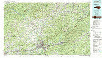
~ Asheville NC topo map, 1:100000 scale, 30 X 60 Minute, Historical, 1985, updated 1985
Asheville, North Carolina, USGS topographic map dated 1985.
Includes geographic coordinates (latitude and longitude). This topographic map is suitable for hiking, camping, and exploring, or framing it as a wall map.
Printed on-demand using high resolution imagery, on heavy weight and acid free paper, or alternatively on a variety of synthetic materials.
Topos available on paper, Waterproof, Poly, or Tyvek. Usually shipping rolled, unless combined with other folded maps in one order.
- Product Number: USGS-5374764
- Free digital map download (high-resolution, GeoPDF): Asheville, North Carolina (file size: 37 MB)
- Map Size: please refer to the dimensions of the GeoPDF map above
- Weight (paper map): ca. 55 grams
- Map Type: POD USGS Topographic Map
- Map Series: HTMC
- Map Verison: Historical
- Cell ID: 67066
- Scan ID: 161867
- Imprint Year: 1985
- Woodland Tint: Yes
- Aerial Photo Year: 1984
- Edit Year: 1985
- Datum: NAD27
- Map Projection: Universal Transverse Mercator
- Map published by Tennessee Valley Authority
- Map Language: English
- Scanner Resolution: 600 dpi
- Map Cell Name: Asheville
- Grid size: 30 X 60 Minute
- Date on map: 1985
- Map Scale: 1:100000
- Geographical region: North Carolina, United States
Neighboring Maps:
All neighboring USGS topo maps are available for sale online at a variety of scales.
Spatial coverage:
Topo map Asheville, North Carolina, covers the geographical area associated the following places:
- Wing - Luther - Jeter (historical) - Grovestone - Rattlesnake Lodge - Georgetown - Fines Creek - Ivy - Bald Mountain - Sevier - Stackhouse - Dendron - Possumtrot - Moffitt Hill - Walnut Creek - Palm (historical) - Center Pigeon - New Candler - Asheville - English - Fairway Hills - Bald Creek - Double Island - Owltown - Kalmia - Ebbs Mill - Altapass - Old Fort - Spring Creek - Gashes Creek - Hurricane - Higgins - Barnardsville - Kenilworth - Hillcrest Apts - Camelot - Foster Creek - Spring Time - Jupiter - Albemarle - Big Laurel - West Canton - Teague (historical) - Candler - Bee Log - Rockview - Canto - Lincoln Park - Biltmore Forest - Hot Springs - Emma - Sandy Bottom - Revere - Murchison - Woodlawn - Plott Farm Addition - Lunday - Jugtown - Grassy Creek - Rice Bend - Lee Walker Hots - Penland - Antioch - Riverside - Little Creek - Parkway Forest - Iron Duff - Flat Creek - Allenstand - Wind Oaks Town Homes - Eskota - Davistown - Woodfin - Boomer - Stockwood - Linwood Park - Hankins - Bowditch - Lanceville - California - Venable - Candler Heights - Green Mountain - Toledo - Broadview - Wasp - Woodside Hills - Deaver View - Marshall - Weaverville - Haw Creek - Ivy Ridge - Estatoe - Forks of Ivy - Woolsey - Bowlens Creek - Hepco (historical) - Marion - Boonford - Allegheny
- Map Area ID: AREA3635.5-83-82
- Northwest corner Lat/Long code: USGSNW36-83
- Northeast corner Lat/Long code: USGSNE36-82
- Southwest corner Lat/Long code: USGSSW35.5-83
- Southeast corner Lat/Long code: USGSSE35.5-82
- Northern map edge Latitude: 36
- Southern map edge Latitude: 35.5
- Western map edge Longitude: -83
- Eastern map edge Longitude: -82


