
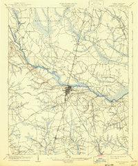
~ Winterville NC topo map, 1:62500 scale, 15 X 15 Minute, Historical, 1905, updated 1942
Winterville, North Carolina, USGS topographic map dated 1905.
Includes geographic coordinates (latitude and longitude). This topographic map is suitable for hiking, camping, and exploring, or framing it as a wall map.
Printed on-demand using high resolution imagery, on heavy weight and acid free paper, or alternatively on a variety of synthetic materials.
Topos available on paper, Waterproof, Poly, or Tyvek. Usually shipping rolled, unless combined with other folded maps in one order.
- Product Number: USGS-5374756
- Free digital map download (high-resolution, GeoPDF): Winterville, North Carolina (file size: 7 MB)
- Map Size: please refer to the dimensions of the GeoPDF map above
- Weight (paper map): ca. 55 grams
- Map Type: POD USGS Topographic Map
- Map Series: HTMC
- Map Verison: Historical
- Cell ID: 64650
- Scan ID: 164067
- Imprint Year: 1942
- Survey Year: 1903
- Datum: Unstated
- Map Projection: Polyconic
- Map published by United States Geological Survey
- Map Language: English
- Scanner Resolution: 600 dpi
- Map Cell Name: Winterville
- Grid size: 15 X 15 Minute
- Date on map: 1905
- Map Scale: 1:62500
- Geographical region: North Carolina, United States
Neighboring Maps:
All neighboring USGS topo maps are available for sale online at a variety of scales.
Spatial coverage:
Topo map Winterville, North Carolina, covers the geographical area associated the following places:
- Westhaven - Alvah Hardy Jr Mobile Home Park - Heritage Village - Camelot - Rollingwood - Evans Trailer Park - Batts Court - Bedford - Cambridge - Baytree - Hartington and Williams - Johnston Heights - Planters Walk - Whichard - Frog Level - Rolling Meadows - Arbor Hills - Stratford - Tucker Estates - Hollywood Crossroads - Paige - Quail Ridge - United Industrial Park - Hills Estate Mobile Home Park - New Belden - Lake Ellsworth - Cherry Oaks - USAR Center - Greyleigh - Meadowbrook - House - Oakhurst - Westwood - Sedgefield - Rock Springs - Buck Mobil Home Park - Belvedere - Riverdale - Stokes - Worthingtons Crossroads - Oakmont - Minnie Bert - Bells Crossroads - Highland Mobile Home Park - Jacksons Trailer Park - Green Farm - Dellwood - Hollands - Canterbury - Clevewood - Paramore Farm - Hardee Acres - Golden Place - Chatham Circle - Forest Hills - Carolina Heights - Wilson Acres - Candlewick Estates - Evans Mobile Home Park - Green Springs - Highland Mobile Home Park - Sheraton Place - Twin Creek - Hudsons Crossroads - Simpson - Brittany Ridge - Lakewood Pines - Baywood - Scarborough - Club Pines - Galloway Crossroads - Country Paradise Mobile Home Park - Red Oak - Belvoir - Sherwood Greens - McGowans Crossroads - Windsor - Oakdale - College View - Brook Valley - Speight - Chad Mobile Home Park - Lincoln Park - Galloway Farms - Bruce - Rock Spring - Greenville - Williamsburg Manor North - Eastwood - Biltmore - Greenville Heights - Treetops - Devonshire Square - Eagle Ridge Mobile Home Park - Drexelbrook - Robinson Heights - River Hills - Greenbrier - Coghill - Eastwood Mobile Home Park
- Map Area ID: AREA35.7535.5-77.5-77.25
- Northwest corner Lat/Long code: USGSNW35.75-77.5
- Northeast corner Lat/Long code: USGSNE35.75-77.25
- Southwest corner Lat/Long code: USGSSW35.5-77.5
- Southeast corner Lat/Long code: USGSSE35.5-77.25
- Northern map edge Latitude: 35.75
- Southern map edge Latitude: 35.5
- Western map edge Longitude: -77.5
- Eastern map edge Longitude: -77.25


