
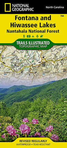
Fontana and Hiwasee Lakes and Nantahala National Forest, Map 784 by National Geographic Maps
• Waterproof • Tear-Resistant • Topographic Map
Nestled in between the Cherokee and Chattahoochee National Forests, lies Nantahala National Forest with its abundance of recreational opportunities. National Geographics Trails Illustrated map of Fontana and Hiwassee Lakes delivers extensive detail and valuable information to assist you in your exploration of this forest. Expertly researched and created in cooperation with the U.S. Forest Service and others, this map features popular points of interest including Nantahala and Chatuge Lakes; Joyce Kilmer Slickrock and Citico Creek Wilderness areas; and Snowbird and Unicoi Mountains.
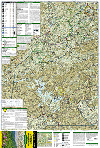
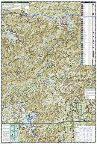
Handy activity guides with help you narrow down areas to visit according to your needs and interests. Trail charts, with hundreds of miles of trails, will help you choose a trail thats right for your activity level and recreation use whether youre hiking, horseback riding, mountain biking, or ATVing, The Appalachian, Benton MacKaye and Bartram Trails are all highlighted. Mountain Waters, Indian Lakes, Nantahala and Cherohala Skyway Scenic Byways are noted for those wishing to explore the region by car. To aid in your navigation, the map also displays shaded relief, contour lines with elevations, water features and areas of private land. Some of the many recreation features noted include campgrounds and campsites, boat ramps and marinas, river and whitewater access points, fishing and swimming areas, lookout towers, wildlife viewing areas and scenic overlooks. Provided also are background information of Nantahala National Forest and Appalachian Trail, bear safety tips and essential contact information.
Every Trails Illustrated map is printed on Backcountry Tough waterproof, tear-resistant paper. A full UTM grid is printed on the map to aid with GPS navigation.
Other features found on this map include: Chattahoochee National Forest, Chatuge Lake, Cheoah Mountains, Cherokee National Forest, Citico Creek Wilderness, Fontana Lake, Great Smoky Mountains, Haw Knob, Hiwassee Lake, Joyce Kilmer-Slickrock Wilderness, Nantahala Mountains, Nantahala National Forest, Snowbird Mountains, Southern Nantahala Wilderness, Unicoi Mountains, Valley River Mountains.
- Product Number: 2034668M
- Product Code: TI_FONTANA
- Publisher Product ID: TI00000784
- ISBN: 9781566953337
- Year of Publication: 2010
- Folded Size: 9.45 x 4.33 inches
- Unfolded Size: 37.01 x 24.8 inches
- Map type: Folded Map
- Geographical region: North Carolina


