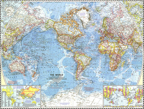
1960 World Map
The National Geographic 1960 World map was published in the midst of sweeping changes in Africa, as many countries gained their independence. This map shows all the changes that had been made as of September, 1960, when the map went to press. Bright boundaries highlight international borders, and the map features extrordinary detail on land and in the oceans. A perfect map for anyone interested in the changes from colonialism to independent rule in Africa.
- Product Number: PODHNG_WOR_60
- Reference Product Number: 2321730M
- ISBN: - None -
- Date of Publication: 6/1/1960
- Unfolded (flat) Size: 18.75 inches high by 24.75 inches wide
- Map format: Wall
- Map type: Trade Maps - Wall Art


