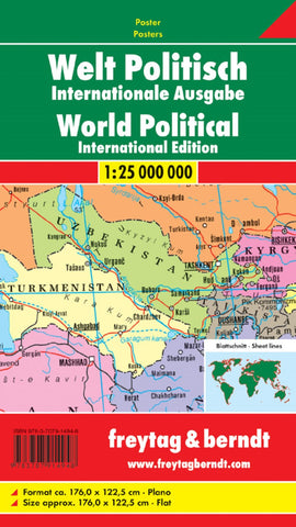
World political (international edition), 1:25. 000,000., Large scale, wall map
Large size, 176x122.5cm (69x48 approx), political wall map of the world from Freytag & Berndt in an international edition with all place names in their English versions, presenting countries in pleasant pastel colours against light blues seas.
On landmasses the map shows main road and rail connections; in USA, Canada, Brazil and Australia also shown are names and boundaries of states/provinces. Physical relief is indicated by names of mountain ranges, peaks, deserts, etc. Polar Regions are presented on insets, showing limits of drift ice and the ice shelf. Latitude and longitude lines are drawn at 10º intervals. Boxes along the sides and the bottom of the map shows each country’s flag, capital city, area and population. Map legend includes English.
PLEASE NOTE: this wall map is also available in a smaller 122x86cm version. To see the other versions please click on the series link.
- Product Number: FB_WOR_WA_14
- Reference Product Number: - None -
- ISBN: 9783707914948
- Date of Publication: 1/27/2014
- Unfolded (flat) Size: 48.14 inches high by 69.17 inches wide
- Map format: Wall
- Map type: Trade Maps - Political