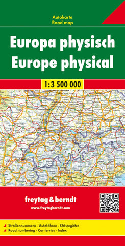
Europe physical, road map 1:3.500,000
Europe at 1:3,500,000 on an indexed map from Freytag & Berndt providing an overview of the road network on a base with relief shading to indicate the topography. Coverage extends beyond Moscow and to the eastern coastline of the Black Sea, with northern Scandinavia and Finland shown on an inset at a less detailed scale.
Relief shading with names of mountain rages shows the topography. Country borders are clearly marked. Country names are indicated by the codes used on car number plates (FR, D, CZ, PL, etc.); names of cities are as used in their countries, so München, Warszawa, Firenze, Athina, etc. In Greece and countries using Cyrillic alphabet place names are in the Latin alphabet only. The map shows the network of motorway routes with connecting regional and selected other roads. Driving distances are shown on main roads. The map also shows principal rail connections and airports. Latitude and longitude lines are drawn at 2º30’ intervals. The index is on the reverse. Map leg
- Product Number: FB_EUR_PHY_22
- Reference Product Number: - None -
- ISBN: 9783707903027
- Date of Publication: 7/5/2022
- Folded Size: 10.02 inches high by 5.11 inches wide
- Unfolded (flat) Size: 10.02 inches high by 5.11 inches wide
- Map format: Folded
- Map type: Trade Maps - Physical