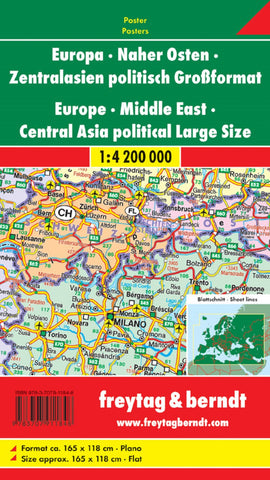
Europa - Naher Osten - Zentralasien, politisch, Großformat, 1:4,200,000., Poster = Europe - Middle East - Central Asia, political, large scale, 1:4.200,000
Political map of Europe at 1:5,500,000 from Freytag & Berndt with the Mediterranean coast of Africa and parts of the Middle East and Central Asia, extending out to Novosibirsk, Tashkent and Dubai – please see our coverage image as the title suggests a wider coverage than actually shown on the map.
Within Europe names of countries and cities are given in their original versions (Österreich/Wien, Polska/Warszawa, etc); elsewhere country names are in English but cities as in the country itself (Dimashq, Al Qahira, etc). Each country also has its international car plates abbreviation. In countries using alphabets other than Latin, all place names are shown transliterated.
The map shows the network of principal and selected secondary roads, many with driving distances, main railway lines, ferry connections and numerous local airports. Topography is indicated by spot heights and in desert areas wells are marked. Latitude and longitude lines are drawn at 5°. The index is on th
- Product Number: FB_EUR_ME_CA_WA_12
- Reference Product Number: - None -
- ISBN: 9783707911848
- Date of Publication: 9/27/2012
- Unfolded (flat) Size: 46.37 inches high by 64.85 inches wide
- Map format: Wall
- Map type: Trade Maps - Political