
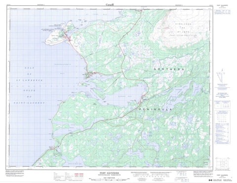
012I11 Port Saunders Canada topo map, 1:50,000 scale
012I11 Port Saunders NRCAN topographic map.
Includes UTM and GPS geographic coordinates (latitude and longitude). This 50k scale map is suitable for hiking, camping, and exploring, or you could frame it as a wall map.
Printed on-demand using high resolution, on heavy weight and acid free paper, or as an upgrade on a variety of synthetic materials.
Topos available on paper, Waterproof, Poly, or Tyvek. Usually shipping rolled, unless combined with other folded maps in one order.
- Product Number: NRCAN-012I11
- Parent Topo: TOPO-012I
- Map ID also known as: 012I11, 12I11
- Unfolded Size: Approximately 26" high by 36" wide
- Weight (paper map): ca. 55 grams
- Map Type: POD NRCAN Topographic Map
- Map Scale: 1:50,000
- Geographical region: Newfoundland and Labrador, Canada
Neighboring Maps:
All neighboring Canadian topo maps are available for sale online at 1:50,000 scale.
Purchase the smaller scale map covering this area: Topo-012I
Spatial coverage:
Topo map sheet 012I11 Port Saunders covers the following places:
- Back Arm - Bad Bay - Barbace Cove - Bustard Cove - Daves Cove - Double Decks Cove - Gargamelle Cove - Gobineau Bay - Golfe du Saint-Laurent - Gulf of St. Lawrence - Hawk Bay - Hawkes Bay - Hawkes Harbour - Ingornachoix Bay - Keppel Harbour - Parsons Cove - Port au Choix - Port Saunders - Sams Cove - St. John Bay - Strawberry Cove - Trappers Cove - Hawke Flat - Barbace Point - Black Point - Blanche Point - Burntwood Point - Catoche Point - Cible Point - Cods Tail - Dunlop Spit - Fox Point - Grass Point - Great Point - Gull Point - Hawke Point - Jenkinson Point - Kent Point - Keppel Point - Laignet Point - Lossieux Point - Mark Point - Morue Spit - Northern Peninsula - Ourson Point - Pointe Riche - Pointe Riche Peninsula - Port au Choix Peninsula - Round Hummock - Saunders Point - Southern Point - Spirity Point - Two Hills Point - Number One Dam - Arctic Island - Benie Island - Gull Island - Keppel Island - Querré Island - Robinson Island - Round Island - Savage Island - Airport Pond - Angle Pond - Beaver House Pond - Beaver Pond - Beaver Pond - Big House Pond - Black Duck Pond - Bryants Raft Pond - Caines Pond - Coles Pond - Forked Feeder Pond - Forky Feeder - Gilmores Pond - Graveyard Pond - Gull Pond - High Pond - Indian Pond - Indian Steady - Indian Steady - Inside Little Brook Pond - Island Pond - Jims Pond - Jones Pond - Kings Cove - Line Road Pond - Little Brook Pond - Little Otter Pond - Little Raft Pond - Long Pond - Long Steady - Long Steady - Main Park Pond - Majors Pond - Middle Pond - Mile Pond - Mudhole - Nells Pond - Nells Pond - Otter Pond - Otter Pond - Philpots Pond - Plowmans Pond - Plowmans Raft Pond - Porters Pond - Rapes Pond - Rat Pond - River of Ponds Lake - Rushy Pond - Sandy Cove Pond - Silver Pond - Slab Pond - Spring Pond - Stag Pond - Stave Pond - Stave Pond - Tilt Pond - Tom Taylors Pond - Twin Pond - Unknown Pond - West Lake - Western Brook Pond - Whale Factory Pond - Whaleback Pond - Highlands of St. John - Long Range Mountains - Number One Ridge - Two Tree Hill - Wolf Hills - Lieu historique national du Canada de Port au Choix - Port au Choix National Historic Site of Canada - River of Ponds Provincial Park - Allan Brook - East River - Eddies Brook - Little Brook - Little East River - River of Ponds - Silver Brook - Torrent River - Ardent Rock - Cible Shoal - Commander Shoal - Cook Bank - English Bank - Gull Shoal - Le Malouin - Montaignac Rock - Pointe Riche Rock - Sauvageon Rock - Hawke's Bay - Port au Choix - Port Saunders - River of Ponds - Eddies Cove West - Eddird Cove West - Gargamelle - Hawke Bay - Spirity Cove - Arctic Mesh - High Mesh - Plowmans Mesh - Hawkes Bay


