
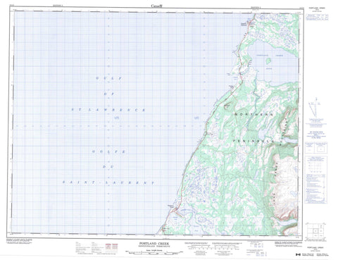
012I04 Portland Creek Canada topo map, 1:50,000 scale
012I04 Portland Creek NRCAN topographic map.
Includes UTM and GPS geographic coordinates (latitude and longitude). This 50k scale map is suitable for hiking, camping, and exploring, or you could frame it as a wall map.
Printed on-demand using high resolution, on heavy weight and acid free paper, or as an upgrade on a variety of synthetic materials.
Topos available on paper, Waterproof, Poly, or Tyvek. Usually shipping rolled, unless combined with other folded maps in one order.
- Product Number: NRCAN-012I04
- Parent Topo: TOPO-012I
- Map ID also known as: 012I04, 12I4, 12I04
- Unfolded Size: Approximately 26" high by 36" wide
- Weight (paper map): ca. 55 grams
- Map Type: POD NRCAN Topographic Map
- Map Scale: 1:50,000
- Geographical region: Newfoundland and Labrador, Canada
Neighboring Maps:
All neighboring Canadian topo maps are available for sale online at 1:50,000 scale.
Purchase the smaller scale map covering this area: Topo-012I
Spatial coverage:
Topo map sheet 012I04 Portland Creek covers the following places:
- Daniel's Cove - Golfe du Saint-Laurent - Gulf of St. Lawrence - Portland Cove - Sandy Bay - Cliffy Point - Eastern Head - Northern Peninsula - The Arches - Moulting Pond - Parsons Pond - Portland Creek Pond - Long Range Mountains - Portland Hill - West Hill - Arches Provincial Park - Bowing Brook - East Brook - Greavett Brook - Parsons Pond River - Portland Creek - Brown Shoal - Daniel's Harbour - Parson's Pond - Portland Creek - Three Mile Rock


