
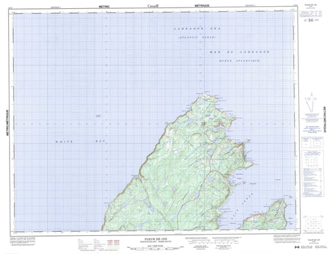
012I01 Fleur De Lys Canada topo map, 1:50,000 scale
012I01 Fleur De Lys NRCAN topographic map.
Includes UTM and GPS geographic coordinates (latitude and longitude). This 50k scale map is suitable for hiking, camping, and exploring, or you could frame it as a wall map.
Printed on-demand using high resolution, on heavy weight and acid free paper, or as an upgrade on a variety of synthetic materials.
Topos available on paper, Waterproof, Poly, or Tyvek. Usually shipping rolled, unless combined with other folded maps in one order.
- Product Number: NRCAN-012I01
- Parent Topo: TOPO-012I
- Map ID also known as: 012I01, 12I1, 12I01
- Unfolded Size: Approximately 26" high by 36" wide
- Weight (paper map): ca. 55 grams
- Map Type: POD NRCAN Topographic Map
- Map Scale: 1:50,000
- Geographical region: Newfoundland and Labrador, Canada
Neighboring Maps:
All neighboring Canadian topo maps are available for sale online at 1:50,000 scale.
Purchase the smaller scale map covering this area: Topo-012I
Spatial coverage:
Topo map sheet 012I01 Fleur De Lys covers the following places:
- Barry's Cove - Big Pardee Cove - Birchy Cove - Bishie Cove - Caplin Cove - Coachman's Harbour - Cook In Cove - Deer Cove - Devil's Cove - Fleur de Lys Harbour - Hard Bay - Little Bay Head Cove - Little Lobster Harbour - Lower Green Cove - Lower Pardee Cove - Marble Cove - Ming's Bight - North Cove - Pigeon Cove - Plat Bay Cove - Seal Cove - Slaughter House Cove - South Cove - White Bay - Woody Cove - Baie Verte Peninsula - Barry's Cove Point - Big Head - British Point - Cape Crapaud - Cape Etat - Capta Head - Capta Head Point - Devil's Cove Head - Duck Island Cove Point - Eastern Point - Flat Point - Fords Point - Green Point - Green Point - Lewis Point - Logy Point - Marble Cove Point - Northern Peninsula - Paradise Point - Partridge Point - Point Rousse - Red Point - Slaughter House Cove Point - Starboard Point - Western Point - White Point - Boat Pass - Fox Gulch - Black Cliff - French Island - Gentille Island - Grassy Island - Guibert Island - Ming's Islands - Pigeon Island - Tin Pot Islands - Barry's Pond - Beaver Pond - Bishie Pond - Caplin Ponds - Cat Path Pond - Devil's Cove Pond - First Pond - Partridge Point Pond - Second Pond - Third Pond - Bear Hill - Fleur de Lys Hill - Barry's Brook - Caplin Cove Brook - Fleur de Lys River - Lower Duck Island Cove Brook - Slaughter House Cove Brook - Wild Cove Brook - North Rock - South Rocks - The Sisters - Coachman's Cove - Fleur de Lys


