
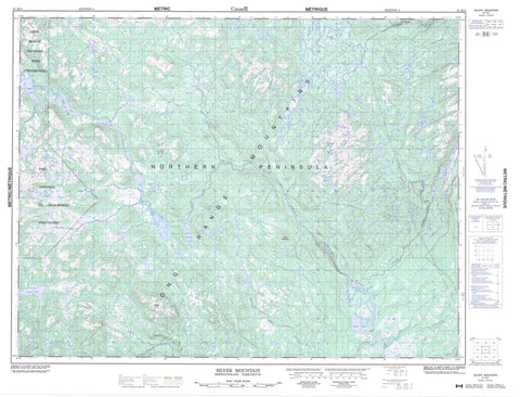
012H11 Silver Mountain Canada topo map, 1:50,000 scale
012H11 Silver Mountain NRCAN topographic map.
Includes UTM and GPS geographic coordinates (latitude and longitude). This 50k scale map is suitable for hiking, camping, and exploring, or you could frame it as a wall map.
Printed on-demand using high resolution, on heavy weight and acid free paper, or as an upgrade on a variety of synthetic materials.
Topos available on paper, Waterproof, Poly, or Tyvek. Usually shipping rolled, unless combined with other folded maps in one order.
- Product Number: NRCAN-012H11
- Parent Topo: TOPO-012H
- Map ID also known as: 012H11, 12H11
- Unfolded Size: Approximately 26" high by 36" wide
- Weight (paper map): ca. 55 grams
- Map Type: POD NRCAN Topographic Map
- Map Scale: 1:50,000
- Geographical region: Newfoundland and Labrador, Canada
Neighboring Maps:
All neighboring Canadian topo maps are available for sale online at 1:50,000 scale.
Purchase the smaller scale map covering this area: Topo-012H
Spatial coverage:
Topo map sheet 012H11 Silver Mountain covers the following places:
- Northern Peninsula - Abe Gales Pond - Angus Lake - Beaver Pond - Big Pond - Birchy Basin - Birchy Lake - Bottle Pond - Burnt Hill Lakes - Deadmans Pond - Deer Pond - Dory Pond - Duck Hole - Hoovers Steady - Job Gillinghams Pond - Lynns Pond - Mattys Pond - Muddy Hole - Nineteen Island Pond - Pork Chop Pond - Puzzle Pond - Rocky Hill Pond - Round Pond - Sandy Pond - Side Pond - Silver Mountain Pond - Taylors Pond - Tenderfoot Pond - Thousand Island Pond - Twin Ponds - Bear Mountain - Long Range Mountains - Rocky Hill - Silver Mountain - Gros Morne National Park of Canada - Gros Morne National Park World Heritage Site - Parc national du Canada du Gros-Morne - Site du patrimoine mondial du Parc national du Gros-Morne - Adies River - Alder Brook - Bill Woolridges Brook - East Adies River - Gales Brook - Main River - North Branch Brook - Northeast Adies River - Taylors Brook - Upper Humber River - Whites River - Birchy Forks - Birchy Flats


