
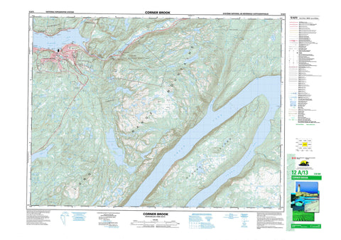
012A13 Corner Brook Canada topo map, 1:50,000 scale
012A13 Corner Brook NRCAN topographic map.
Includes UTM and GPS geographic coordinates (latitude and longitude). This 50k scale map is suitable for hiking, camping, and exploring, or you could frame it as a wall map.
Printed on-demand using high resolution, on heavy weight and acid free paper, or as an upgrade on a variety of synthetic materials.
Topos available on paper, Waterproof, Poly, or Tyvek. Usually shipping rolled, unless combined with other folded maps in one order.
- Product Number: NRCAN-012A13
- Parent Topo: TOPO-012A
- Map ID also known as: 012A13, 12A13
- Unfolded Size: Approximately 26" high by 36" wide
- Weight (paper map): ca. 55 grams
- Map Type: POD NRCAN Topographic Map
- Map Scale: 1:50,000
- Geographical region: Newfoundland and Labrador, Canada
Neighboring Maps:
All neighboring Canadian topo maps are available for sale online at 1:50,000 scale.
Purchase the smaller scale map covering this area: Topo-012A
Spatial coverage:
Topo map sheet 012A13 Corner Brook covers the following places:
- Bay of Islands - Brake Cove - Brakes Cove - Bucket Cove - Church Cove - Curling Cove - Humber Arm - Northern Harbour - Pettipas Cove - Wild Cove - The Bar - Bear Head - Brake Point - Brakes Point - Crow Head - Dancing Point - DeGrouchy Point - Grand Pond Point - Inner Aspen Point - Johns Point - Pettipas Point - Rood Point - Seal Head - Tucker Head - The Narrows - Corner Brook - Glover Island - Shellbird Island - Abel Pond - Angle Pond - Angle Pond - Annette Pond - Aye Pond - Bairds Pond - Bar Pond - Bee Pond - Big Feeder Pond - Blue Gulch Pond - Breeches Pond - Cain Pond - Caribou Lake - Cecile Pond - Cee Pond - Corner Brook Lake - Cove Pond - Dee Pond - Diamond Pond - East Branch Pond - Eastern Lake - Eel Pond - First Pond - Fox Bow Lake - Frying Pan Pond - Glynmill Pond - Grand Lake - Gullet Pond - Howes Pond - Island Pond - Island Pond - Island Pond - Lady Slipper Pond - Line Pond - Link Pond - Livingston Pond - Meadows Pond - Middle Pond - Millie Pond - Muddy Pond - Muskrat Pond - Narrow Pond - Normans Pond - North Pond - Oxbow Pond - Parsons Pond - Pinchgut Lake - Pynns Pond - Rapid Pond - Rat Pond - Rocky Pond - Round Pond - Rubber Lake - Sandy Pond - Southwest Pond - Steady Brook Lake - Strattons Pond - Tea Pond - Third Pond - Three Corner Pond - Tippings Pond - Transmission Pond - Trout Pond - Valley Lakes - Watsons Pond - Whale Back Pond - White Lake Pond - Wild Cove Lake - Yvonne Pond - American Man - Bells Hill - Crow Hill - Duncans Rock - Long Range Mountains - Marble Mountain - Mount Musgrave - Mount Patricia - Taylors Nose - The Old Man - Glover Island Public Reserve - Newfoundland T'Railway Provincial Park - Stag Lake Provincial Park - Bells Brook - Big Feeder Brook - Black Gulch Brook - Burnt Hill Brook - Camp Eleven Brook - Carp Creek - Condon Brook - Connors Brook - Conway Brook - Corner Brook - Crooked Brook - Deep Gulch Brook - Duncan Brook - East Steady Brook - Hughes Brook - Humber River - Irishtown Brook - Island Pond Brook - Lady Slipper Brook - Little Feeder Brook - Little Rapids Brook - Matthews Brook - Meadows Brook - Muskrat Brook - O'Rourke Brook - Parsons Brook - Porters Brook - Pynns Brook - Salmon Creek - South Bells Brook - South Brook - St. Marys Brook - Stag Hill Brook - Steady Brook - Transmission Brook - Trout Creek - Watsons Brook - Whale Back Brook - Whitefish Creek - Wild Cove Brook - Yellow Marsh Brook - Corner Brook East - Corner Brook West - Curling - Hughes Brook - Humbermouth - Irishtown-Summerside - Massey Drive - Pasadena - Pasadena-Midland - Steady Brook - Country Road Industrial Park - Dogwood - Harrison - Humber Village - Irishtown - Little Rapids - Maple Valley Industrial Park - Marble Mountain Ski Area - Midland - Russell - Steady Brook Bridge - Summerside - Watsons Pond Industrial Park - Crow Gulch - Yellow Marsh


