
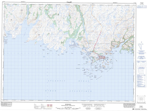
011P12 Burgeo Canada topo map, 1:50,000 scale
011P12 Burgeo NRCAN topographic map.
Includes UTM and GPS geographic coordinates (latitude and longitude). This 50k scale map is suitable for hiking, camping, and exploring, or you could frame it as a wall map.
Printed on-demand using high resolution, on heavy weight and acid free paper, or as an upgrade on a variety of synthetic materials.
Topos available on paper, Waterproof, Poly, or Tyvek. Usually shipping rolled, unless combined with other folded maps in one order.
- Product Number: NRCAN-011P12
- Parent Topo: TOPO-011P
- Map ID also known as: 011P12, 11P12
- Unfolded Size: Approximately 26" high by 36" wide
- Weight (paper map): ca. 55 grams
- Map Type: POD NRCAN Topographic Map
- Map Scale: 1:50,000
- Geographical region: Newfoundland and Labrador, Canada
Neighboring Maps:
All neighboring Canadian topo maps are available for sale online at 1:50,000 scale.
Purchase the smaller scale map covering this area: Topo-011P
Spatial coverage:
Topo map sheet 011P12 Burgeo covers the following places:
- Aaron Arm - Aaron Arm - Back Cove - Barasway Bay - Bay de Loup - Billiard Cove - Burgeo Port - Burnt Head Cove - Connoire Bay - Deep Cove - Doctor Harbour - First Arm - Gilham Cove - Golfe du Saint-Laurent - Gulf of St. Lawrence - Indian Hole - Kings Harbour - Long Will Hole - Mercer Cove - Moon Cove - Muddy Hole - Muddy Hole Bay - Northeast Arm - Northwest Arm - Northwest Arm - Red Island Harbour - Ship Dock Cove - Sots Hole - The Ha Ha - Tilt Cove - West Muddy Hole - Wreck Island Harbour - Aldridge Head - Barasway Point - Bay de Loup Point - Bell Head - Burnt Head - Charlie Head - Connoire Head - Coombes Head - Crow Head - East Point - Fox Point - Furber Point - Gilham Head - Grip Head - Harbour Point - Kelpy Cove Point - Kings Head - Little Barasway Head - Little Gut Head - Maze Point - Mercer Point - Mid Head - Middle Head - Middle Woods - Muddy Hole Point - Murray Point - Norman Head - Otter Point - Potato Point - Red Head - Richards Head - Sand Spit - Sandbanks Point - The Nuddick - The Nuddick - Tom Rock Head - Western Point - Little Gut - The Canal - Blow Me Down - Aaron Island - Baggs Island - Baring Island - Boar Island - Buffetts Island - Burgeo Islands - Burnt Islands - Colombier Island - Coombes Islands - Cornelius Island - Crocker Island - Cuttail Island - Doctor Island - Duck Island - Eclipse Island - Fish Island - Flannagan Island - Flat Island - Franks Island - Fryingpan - Goose Island - Grandy Island - Green Island - Green Island - Green Island - Greenhill Island - Grip Island - Gull Island - Gun Island - Harbour Island - Hug My Dug Island - Hunt's Island - Jack Island - Little Boar Island - Little Colombier Island - Little Rencontre Island - Miffel Island - Morgan Island - Musket Islands - Pigeon Island - Piper Island - Poll Island - Puffin Island - Ragged Island - Rencontre Island - Round Island - Round Shag Island - Salmon Net Island - Sandbanks Point Island - Seal Islands - Shag Island - Smalls Island - South Shag Island - Spritsail Island - The Baldwin - The Friar - Turks Island - Venils Island - West Flat Island - White Island - Wreck Island - Big Barachois - Big Barasway - Cowlest Barasway - Gull Pond - Little Barasway - Cobbler Hill - Cow House Hill - Father Hughes Hill - Forked Hills - Round Hill - Six Mile Hill - The Louse Box - Trimming Hill - Woody Hill - Sandbanks Provincial Park - Bay de Loup Brook - Cutts Brook - First Brook - Grandy Brook - Kelly Brook - Kings Harbour Brook - Middle Brook - Rattling Brook - Seal Brook - Seal Brook - Wooden Tilt Brook - Woody Hill Brook - Long Reach - Short Reach - Aldridge Rock - Baldwin Shoal - Bateau Rock - Bay de Loup Rock - Billy Bump Shoal - Black Rock - Black Rock - Black Rock - Boar Island Rock - Boar Island Shoal - Charlie Rock - Charlie Rock - Charlie Rock - Circular Rocks - Clam Bank - Cloven Cod - Connoire Bank - Connoire Offer Part - Cross Rocks - Dick Rock - Fish Island Rock - Fish Rock - Flat Island Shoal - Fortune Rock - Galloping Moll - Graley Rock - Grandfather Rock - Green Island Rocks - Green Island Rocks - Green Island Shoal - Green Rock - Halibut Rock - Harbour Island Rock - Jumper Shoal - Killock Shoal - Little Rencontre Rocks - Longboat Rocks - Marchand Rock - Mark Rocks - Miffel Rocks - Mile Rocks - Nags Head Shoal - Neverfail - New Mark Rock - No Mans Rock - Offer Shag Island Bank - Offer Shoal - Petit Marchand - Point Shoal - Pot Rock - Rencontre Rock - Saddle Fox - Sam Crew Shoal - Seal Rocks - Seal Rocks Shoal - Slaughter Rock - Stern Rock - The Boar - The Douglas - The Hummock - The Jumper - The Painter - The Sandbanks - The Sow - Tom Cod Rock - Venils Shoal - Western Point Rock - Western Rock - Whales Back - White Ground - White Island Shoal - Winging Rock - Winging Rock - Womans Rock - Wreck Island Bank - Wreck Offer Part - Yankee Rock - Burgeo - Bay de Loup - Doctors Harbour - Our Harbour - Red Island - Upper Burgeo


