
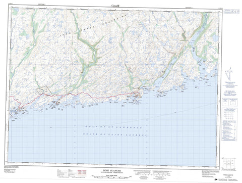
011O10 Rose Blanche Canada topo map, 1:50,000 scale
011O10 Rose Blanche NRCAN topographic map.
Includes UTM and GPS geographic coordinates (latitude and longitude). This 50k scale map is suitable for hiking, camping, and exploring, or you could frame it as a wall map.
Printed on-demand using high resolution, on heavy weight and acid free paper, or as an upgrade on a variety of synthetic materials.
Topos available on paper, Waterproof, Poly, or Tyvek. Usually shipping rolled, unless combined with other folded maps in one order.
- Product Number: NRCAN-011O10
- Parent Topo: TOPO-011O
- Map ID also known as: 011O10, 11O10
- Unfolded Size: Approximately 26" high by 36" wide
- Weight (paper map): ca. 55 grams
- Map Type: POD NRCAN Topographic Map
- Map Scale: 1:50,000
- Geographical region: Newfoundland and Labrador, Canada
Neighboring Maps:
All neighboring Canadian topo maps are available for sale online at 1:50,000 scale.
Purchase the smaller scale map covering this area: Topo-011O
Spatial coverage:
Topo map sheet 011O10 Rose Blanche covers the following places:
- Bay Le Moine - Bennett Cove - Broad Cove - Brown Cove - Burnt Island Harbour - Coney Bay - Dublin Cove - Firmages Cove - Garia Bay - Garia Harbour - God Bay - Golfe du Saint-Laurent - Gulf of St. Lawrence - Harbour Le Cou - Hatchers Cove - Isle aux Morts Harbour - Little Garia Bay - Lobster Cove - Mull Face Bay - Otter Bay - Picot Hole - Pool Cove - Rose Blanche Bay - Rose Blanche Harbour - Salmon Cove - Seal Island Harbour - Shark Cove - Ship Cove - Sosoleil Hole - Spirit Cove - Squid Hole - The Barasway - The Barasway - The Bottom - West Arm - Baker's Point - Beach Point - Berry Point - Brown Cove Point - Butt Head - Carpet Point - Coffin Point - Coney Head - Deer Point - Firmages Head - Fish Head - Fish Point - Garb Point - Grave Point - Green Point - Hiscock's Point - Long Point - Net Cove Point - Net Point - Net Point - Ragged Point - Red Head - Rose Blanche Point - Sarsaparilla Point - Seal Island Head - Shark Cove Head - Shoal Point - Slammer Point - Southeast Point - Stickland Point - White Head - White Point - Eastern Passage - Grandy Passage - Grandy Sound - Middle Passage - Milners Channel - Milners Tickle - Western Passage - Blow Me Down - Burnt Island Bluff - White Cliff - Baker's Island - Baziel Islands - Big Glimbi Island - Big Island - Big Seal Island - Black Island - Burnt Islands - Butt Island - Cains Island - Clarks Island - Colombier Islands - Comber Islands - Deer Island - Duck Island - Duck Island - Firmage's Island - Fox Goose Island - Frenchman Island - Frenchman Island - Goose Island - Great Burnt Island - Green Island - Gull Island - Harbour Island - Hiscock Islands - Hopkins Island - Indian Island - Isle aux Morts - Kitty Island - Little Glimbi Island - Little Grave Island - Little White Island - Lobster Claw Island - Mickle Reach Island - Middle Island - Muskrat Island - Offer Seal Island - Otter Gut Island - Pigeon Island - Pigeon Island - Pitman's Island - Pool Island - Potato Island - Pushthrough Islands - Ragged Island - Round Island - Round Island - Round Island - Salmon Island - Salmon Net Island - Shag Island - Smock Island - Southeast Island - Spruce Island - Squid Island - Tinker Island - White Islands - Winging Island - Woody Island - Wreck Island - Wreck Island - Full Pond - Jackass Pond - Long Lake - Meadows Longs Pond - Northwest Pond - Butterpot Hill - Harry's Knob - Long Range Mountains - Ship Cove Hill - Sugarloaf - The Nuddick - Waterfall - Otter Bay Provincial Park - Burnt Island Brook - Farmers Brook - Garia Brook - Grandys Brook - Isle aux Morts River - Northwest Brook - Northwest Brook - Rose Blanche Brook - Southeast Brook - Bad Neighor - Bakers Ledge - Bay Le Moine Rock - Bell Rock - Bell Rock - Bennett Cove Sunker - Big Rock - Big Shoal - Bight Sunkers - Black Rock - Black Rock - Black Rock - Black Rock - Black Rock - Black Rock - Black Rock Shoal - Black Rock Shoal - Black Rock Sunker - Bob Roger's Shoal - Bob Shoal - Bowdridge Shoal - Brag Rock - Butt Shoal - Calapoose Rocks - Camber Shoal - Connor Rock - Cow Head Shoal - Crew Shoal - Dicky Rock - Dublin Cove Rocks - Duck Rock - Duck Rocks - Eastern Shoal - Edge of Ground - Elias Shoal - Flat Rock - Frenchman Hole - Frenchman Rock - Gob Rock - Green Island Sunkers - Halifax Shoal - Harrys Rock - Hat Rocks - Hill's Rock - Jack Shoal - Jim Shoal - Job Halliday Shoal - Lily Shoal - Little Glim Rock - Lookout Shoal - Major Rock - Middle Bight Shoal - Middle Ground - Middle Hummock - Middle Stick Shoal - Net Shoal - Neverfail Shoal - North Red Head Rock - Offer Bank - Offer Gob Rock - Offer Lookout Shoal - Old Man's Shoal - Passage Shoal - Pigeon Island Shoals - Pigeon Ledge - Pillar Rock - Point Shoal - Pot Rock - Quand Shoal - Raymond Shoal - Red House Shoal - Rose Blanche Bank - Rose Blanche Shoals - Salmon-Net Island Shoal - Sarsaparilla Shoal - Sculpin Rock - Shag Island Shoal - Shag Rocks - Slammer Shoal - Sleepy Shoal - Smith Shoal - South Red Head Rock - Southeast Rock - Southeast Rocks - Southwest Rock - Southwest Shoal - Stickland Shoal - Stone Shoal - Taylor Shoal - The Bull - The Calf - The Cow - The Friar - The Red House - Thibaud Shoal - Tinker Sunker - Touch and Take Shoal - Twin Rocks - Uncle John Shoal - Wash Rocks - Wat Pink Shoal - West Red House Shoal - Western Bight Shoal - Western Shoal - Whale's Back - White Rock - White Sunkers - Whittle Rock - Winging Rock - Winging Rocks - Wreck Island Sunkers - Yankee Rocks - Burnt Islands - Isle aux Morts - Rose Blanche-Harbour Le Cou - Cains Island - Diamond Cove - Harbour Le Cou - Petites - Petites - Rose Blanche - Bay Le Moine Gulch - Burnt Island


