
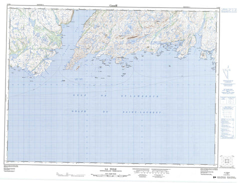
011O09 La Poile Canada topo map, 1:50,000 scale
011O09 La Poile NRCAN topographic map.
Includes UTM and GPS geographic coordinates (latitude and longitude). This 50k scale map is suitable for hiking, camping, and exploring, or you could frame it as a wall map.
Printed on-demand using high resolution, on heavy weight and acid free paper, or as an upgrade on a variety of synthetic materials.
Topos available on paper, Waterproof, Poly, or Tyvek. Usually shipping rolled, unless combined with other folded maps in one order.
- Product Number: NRCAN-011O09
- Parent Topo: TOPO-011O
- Map ID also known as: 011O09, 11O9, 11O09
- Unfolded Size: Approximately 26" high by 36" wide
- Weight (paper map): ca. 55 grams
- Map Type: POD NRCAN Topographic Map
- Map Scale: 1:50,000
- Geographical region: Newfoundland and Labrador, Canada
Neighboring Maps:
All neighboring Canadian topo maps are available for sale online at 1:50,000 scale.
Purchase the smaller scale map covering this area: Topo-011O
Spatial coverage:
Topo map sheet 011O09 La Poile covers the following places:
- Betty Cove - Bevan Cove - Broad Cove - Brown Cove - Cinq Cerf Bay - Couteau Bay - Couteau Cove - Couteau Harbour - Culotte Cove - Fish Head Cove - French Cove - Frenchman Cove - Gallyboy Harbour - Golfe du Saint-Laurent - Grand Bruit Harbour - Grave Cove - Gulf of St. Lawrence - Indian Harbour - La Plante Harbour - La Poile Bay - La Poile Harbour - Little Bay - Little Couteau Bay - Little La Poile - Little La Poile Bay - Little Rôti Bay - Northeast Arm - Outside Cove - Pumbly Cove - Rôti Bay - Sandy Cove - Seal Cove - Seal Cove - The Barasway - The Barasway - The Basin - Turnip Cove - Unicorn Cove - Wild Cove - Wild Cove - Wild Cove - Cow Beach - Baggs Head - Barasway Point - Beacon Point - Betty Head - Black George Head - Blowhole - Christmas Head - Couteau Head - Cow Head - Crafty Head - Deepwater Point - Devil Head - Duck Island Point - East Diver Head - Eastern Point - Friar Head - Gallyboy Head - Grave Cove Point - Horses Head - Ironbound Head - Kennedy Point - Lawrence Point - Long Point - Long Point - Misery Point - North Bay Point - Otters Rub - Pumbly Cove Point - Rôti Point - Sandbank Point - Sandbank Point - Shag Roost Point - Shoal Point - Tooth Head - West Point - Western Head - Wild Cove Head - Wild Cove Point - Woody Point - Pushthrough - Barasway Island - Bass Island - Blackhead Island - Boat Passage Island - Bung Island - Captain Island - Cinq Cerf Islands - Duck Island - Duck Island - Duck Island - Duck Island - Flat Island - Goose Island - Grand Bruit Islands - Green Island - Grip Island - Gull Island - Gull Island - Harbour Island - Harbour Island - Ireland Island - Jacques Island - Jenny Buffet Island - Jones Island - Offer Island - Organ Island - Picaroon Island - Pig Island - Pigeon Island - Pigeon Island - Pigeon Island - Pools Island - Round Island - Salmon Net Island - Sam Island - Sandbank Island - Sandbanks Island - Shag Island - Shag Island - Shot Bag Island - Smoky Island - Southeast Island - Spruce Island - Three Islands - Tinker Island - Vineyard Island - Whale Island - White Island - Woody Island - Barasway Pond - Bettys Pond - Bolo Pond - Flint Cliff Pond - Grand Bruit Gull Pond - Guiders Pond - Gull Pond - Hawks Nest Pond - Inside Gull Pond - Man of War Pond - Northwest Brook Pond - Old Man Pond - Outside Gull Pond - Pine Pond - Sandy Cove Gull Pond - Dinner Box Hill - Highlands of Grand Bruit - Long Range Mountains - Old Man Hill - Whittle Hill - Withy Gulch Hill - Hope Brook Gold Mine - Bakers Brook - Barasway Brook - Black Duck Brook - Broad Cove Brook - Cinq Cerf Brook - Couteau Brook - Farmers Brook - Georges Brook - Hope Brook - Phillips Brook - Rôti Brook - Anchor Shoal - Bad Neighbour - Ben Shoal - Bennett Rock - Big Shoal - Big Sunker - Bight Rock - Bill Bank - Billy Anderson Shoal - Black Rock - Black Rock - Black Rock - Bob Rock - Bob Rock - Capelin Rocks - Chain Shoal - Chance Rock - Chimney Shoal - Cloven Rock - Colombier Shoal - Colombier Shoal - Connor Rock - Copper Duck Rock - Cork Rock - Couteau Colombier - Couteau Flat Rocks - Cox Rock - Diver Reef - Diver Rock - Eastern Bank - Eastern Rocks - Fish Rock - Gob Rock - Grand Bruit Colombier - Griffin Rock - Gull Rock - Gull Rocks - Halibut Ledge - Harbour Rock - Harbour Rock - Harpoon Shoal - Harry Lawrence Shoal - Horses Head - Indian Island Shoal - Inside Big Shoal - Inside Shag Island Shoal - Inside Southwest Shoal - Jim Hodder Shoal - Jim Rocks - Jim Shoal - Lance Spot - Little Colombier Shoal - Lookout - Man Rock - Mid Southwest - Middle Shag Island Bank - Myles Rock - Nail Shoal - Naked Man - Never-be-good - Neverfail - Nipper Shoal - Norman Rock - Offer Anchor - Offer Southwest - Old Man Shoal - Pancake Rock - Picaud Rock - Pike Shoal - Poppy Rock - Rose Blanche Bank - Rôti Colombier - Rôti Rock - Seal Rocks - Seal Rocks - Shoal Ground - South West Shoal - Southeast Rock - Studdles Shoal - Temple Rock - The Bar - The Pinnacle - The Smoker - Tinker Island Shoal - Tinker Rock - Tinker Rocks - Tinker Sunkers - Tom Cod Rock - Tooth Rock - Whaleback - White Ground - White Rock - Grand Bruit - Indian Harbour - La Poile - Otter's Point - West Point


