
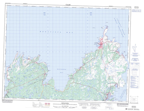
002C11 Bonavista Canada topo map, 1:50,000 scale
002C11 Bonavista NRCAN topographic map.
Includes UTM and GPS geographic coordinates (latitude and longitude). This 50k scale map is suitable for hiking, camping, and exploring, or you could frame it as a wall map.
Printed on-demand using high resolution, on heavy weight and acid free paper, or as an upgrade on a variety of synthetic materials.
Topos available on paper, Waterproof, Poly, or Tyvek. Usually shipping rolled, unless combined with other folded maps in one order.
- Product Number: NRCAN-002C11
- Parent Topo: TOPO-002C
- Map ID also known as: 002C11, 02C11, 2C11
- Unfolded Size: Approximately 26" high by 36" wide
- Weight (paper map): ca. 55 grams
- Map Type: POD NRCAN Topographic Map
- Map Scale: 1:50,000
- Geographical region: Newfoundland and Labrador, Canada
Neighboring Maps:
All neighboring Canadian topo maps are available for sale online at 1:50,000 scale.
Purchase the smaller scale map covering this area: Topo-002C
Spatial coverage:
Topo map sheet 002C11 Bonavista covers the following places:
- Amherst Cove - Back Cove - Backside Cove - Bayleys Cove - Birchy Cove - Black Bay - Blackhead Bay - Bonavista Bay - Bonavista Harbour - Broad Cove - Cable John Cove - Castle Cove - Catalina Harbour - Danson Cove - Deep Cove - Elliston Cove - Fish Point Gulch - Keels Cove - Kings Cove - Knights Cove - Lance Cove - Little Catalina Harbour - Monk Bay - Newmans Cove - Open Hall - Plate Cove - Port Union - Red Cove - Rolling Cove - Shepherd Cove - Southeast Cove - Spillars Cove - Tickle Cove - Wild Bay - Wolf Cove - Southwest Breaker - Arch Cliff Point - Arrow Point - Bare Head - Black Head - Broad Head - Burnt Head - Burnt Point - Burnt Point - Calves Nose - Canaille Point - Cape Bonavista - Cape L'Argent - Civil Head - Courages Point - Cuckold Head - Danson Head - Elliston Point - Flowers Point - Goodland Point - Hiscock's Point - Kings Cove Head - Knights Point - Moses Point - North Head - Rowland Head - Shepherd Point - Southern Head - Spillars Point - Western Head - Wolf Head - Green Island - Green Island - Gull Island - Manuel Island - Manuel Islands - North Bird Island - Red Cliff Island - South Bird Island - Squarry Island - Stone Island - Abbotts Steady - Beaver Pond - Big Pond - Big Rocky Pond - Broad Cove Pond - Chapel Pond - Cliff Pond - Clift Pond - Corn Pond - Daniels Pond - Diamonds Pond - Dog Pond - Dragnet Pond - Drake Pond - Duck Pond - Earth Ponds - Fishers Pond - Fishpoint Pond - Floods Pond - Fowlows Pond - Franeys Pond - Georges Pond - Grassy Steady - Gull Pond - Gully Pond - Hodderville Pond - Hoddey Pond - Horseshoe Pond - Island Pond - Island Pond - Island Pond - Island Pond - Knights Cove Pond - Lewis Pond - Lewis Pond - Little Island Pond - Little Rocky Pond - Long Pond - Long Pond - Long Pond - Lookout Pond - Lukes Pond - Middle Pond - Monkeys Pond - Morgans Pond - Mouse Hill Pond - Nolan Pond - Oar Pond - Plate Cove Big Pond - Plate Cove Pond - Rocky Pond - Round Pond - Saddle Pond - Slate Pond - Stock Cove Big Pond - Swibbs Cove Pond - Telleys Pond - Tickle Cove Pond - Trout Pond - Trout Pond - Trout Pond - Trouty Pond - Twin Ponds - Two Arm Pond - Whirl Pond - Burnt Ridge - Butchers Nose - Geralds Hill - Horse Chops - L'Argent Hill - L'Argent Hill - Snelgroves Hill - The Battery - Dungeon Provincial Park - Lieu historique national du Canada de l'Établissement-Ryan - Maberly Provincial Park - Ryan Premises National Historic Site of Canada - Georges Pond Brook - Bacon Bone Rock - Brandies Shoal - Brandy Rocks - Cary Rock - Charlton Rock - Clam Rock - Dacres Rock - Doctors Ledge - Foggy Rock - Green Ridge - Green Rock - Lowe Rock - Matthews Ground - Pigeon Ledge - Pigeon Rock - Poor Shoal - Red Cove Rock - Red Rock - Skimmerton Ground - Slades Rock - Snurns Ledge - Spillars Ledge - The Brandishes - Tinker Rocks - White Rock - Wizard Rock - Bonavista - Duntara - Elliston - Keels - King's Cove - Little Catalina - Trinity Bay North - Amherst Cove - Birchy Cove - Catalina - Hodderville - Kings Cove - Knights Cove - Lancaster - Lance Cove - Maberly - Middle Amherst Cove - Newmans Cove - Open Hall - Open Hall-Red Cliffe - Plate Cove East - Plate Cove West - Port Union - Red Cliff - Spillars Cove - Spillers Cove - Stock Cove - Tickle Cove - Upper Amherst Cove - Broad Cove


