
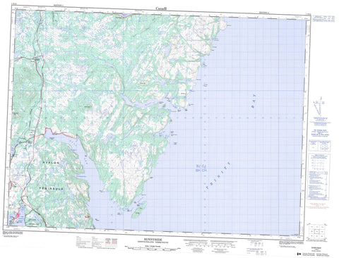
001N13 Sunnyside Canada topo map, 1:50,000 scale
001N13 Sunnyside NRCAN topographic map.
Includes UTM and GPS geographic coordinates (latitude and longitude). This 50k scale map is suitable for hiking, camping, and exploring, or you could frame it as a wall map.
Printed on-demand using high resolution, on heavy weight and acid free paper, or as an upgrade on a variety of synthetic materials.
Topos available on paper, Waterproof, Poly, or Tyvek. Usually shipping rolled, unless combined with other folded maps in one order.
- Product Number: NRCAN-001N13
- Parent Topo: TOPO-001N
- Map ID also known as: 001N13, 01N13, 1N13
- Unfolded Size: Approximately 26" high by 36" wide
- Weight (paper map): ca. 55 grams
- Map Type: POD NRCAN Topographic Map
- Map Scale: 1:50,000
- Geographical region: Newfoundland and Labrador, Canada
Neighboring Maps:
All neighboring Canadian topo maps are available for sale online at 1:50,000 scale.
Purchase the smaller scale map covering this area: Topo-001N
Spatial coverage:
Topo map sheet 001N13 Sunnyside covers the following places:
- Arnold's Cove - Badgers - Bald Head Cove - Balsoms Cove - Big Mosquito Cove - Birch Cove - Bull Arm - Burn Cove - Centre Bay - Centre Cove - Coadys Cove - Come By Chance - Cooking Cove - Deer Harbour - Ferrish Cove - Frenchmans Cove - Garretts Cove - Goose Cove - Goose Cove - Goose Cove - Graper Rock Cove - Great Mosquito Cove - Great Southern Harbour - Green Cove - High Head Cove - Lady Cove - Leonards Cove - Little Harbour - Little Harbour - Little Mosquito Cove - Little Mosquito Cove - Little Stock Cove - Man O'War Cove - Martin Eddys Cove - Muddy Hole - Northeast Arm - Northern Bight - Old Dock - Old Womans Cove - Peddles Cove - Placentia Bay - Pumbly Cove - Rix Harbour - Rock Wood Cove - Round Harbour - Samsons Head Cove - Shag Harbour - Shoal Bay - Shoal Cove - Shoal Harbour - Sibleys Cove - Southeast Arm - Southwest Arm - Southwest Arm - St. Jones Harbour - St. Jones Without - Stock Cove - Strong Tickle - Tea Cove - The Hoof Cove - The Mat - Tom Powers Cove - Tommy Short Cove - Trap Bight - Trinity Bay - Welchs Cove - Come By Chance Beach - Come by Chance Beach - Sandys Beach - Arnolds Cove Peninsula - Avalon Peninsula - Bald Head - Bald Point - Big Burrow - Big Mosquito Point - Big Neck - Centre Point - Deer Harbour Head - Dumpling Point - Fillys Gaze - Goose Cove Point - Goose Head - Goose Point - Green Point - Guys Point - High Head - Isthmus of Avalon - Johns Chin - Little Head - Little Mosquito Point - Little Neck - Net Point - Niagara Point - North Head - Northern Point - Otter Rub Head - Peddles Point - Robinson Point - Samsons Head - Snails Head - Sophia Head - South Head - Southwest Head - Squib Point - Squid Point - St. Jones Head - Stanton Point - Stock Cove Point - Tea Cove Point - Thames Harbour Point - The Chimney - The Hoof - The Mat Point - Tidy Point - Bull Tickle - Come By Chance Gut - Narrows - The Tickle - Big Island - Birch Cove Island - Bull Island - Copper Island - Dog Island - Duck Islands - Frenchmans Island - Gooseberry Island - Green Island - Grub Island - McKay Island - Mouse Islands - Poor Boy Island - Rovers Island - Seal Island - Shag Islands - St. Jones Islands - Thames Island - 101 Ponds - Arnolds Pond - Badgers Pond - Bald Head Pond - Barasway Ponds - Beaver Pond - Big Island Pond - Big Mosquito Pond - Big Pond - Big Pond - Bill Martins Dam Pond - Birchy Pond - Black Duck - Black Duck Pond - Black Pond - Black River Pond - Blue Hill Pond - Bullocks Pond - Burgess HeadPond - Butt Pond - Caplin Cove Pond - Centre Hill Pond - Church Pond - Dam Pond - Dam Pond - Dam Ponds - Davis Pond - Deer Harbour Long Pond - Deer Harbour Pond - Deer Harbour Steady - Dog Rock Cove Pond - Double Gullies - Duck Pond - Esaus Pond - Feeder Ponds - First Long Pond - Foxy Rocks Pond - Frenchmans Pond - Freshwater Pond - Frosts Pond - Gap Pond - Goobies Pond - Goose Cove Pond - Goose Pond - Goose Pond - Goose Pond - Gull Pond - Gull Pond - Gull Pond - Gull Pond - Gull Pond Gully - Happy Pond - Headwater Ponds - Hole Pond - Isaac Johns Pond - Island Pond - Island Pond - Jack Pond - Jacks Pond - Jar Pond - Lady Cove Pond - Layden Pond - Lead of Ponds - Leonards Beach Pond - Lice Pond - Little Feeders - Little Harbour Pond - Little Jacks Pond - Little Mosquito Pond - Long Pond - Long Pond - Long Pond - Long Pond - Long Pond - Mill Cove Ponds - Mill Pond - Mill Pond - Nine Angle Pond - Norris Pond - Northeast Arm Pond - Old Dock Pond - Otter Pond - Peddles Cove Pond - Peddles Pond - Pumbly Cove Pond - Rock Ponds - Rocky Pond - Round Pond - Rushy Pond - Samsons Gully - Samsons Pond - Sandy Beach Ponds - Second Long Pond - Shoal Bay Big Pond - Shoal Bay Pond - Sibleys Cove Pond - Siding Pond - Southern Harbour Pond - Southwest Arm Gully - Spurrells Pond - Spurrells Pond - Stock Cove Gull Pond - Switch Pond - Tea Cove Pond - Third Long Pond - Thomas Ponds - Trout Pond - Trout Pond - Trout Pond - Twillick Pond - Uncle Steves Pond - Valley Ponds - Vee Pond - White Point Pond - Arthurs Hill - Bears Folly - Ben Droke - Ben Droke Mountain - Big Hill - Birch Hill - Blue Hill - Burgess Head - Centre Hill - Crown Hill - Dog Rock Cove Hill - French Rock - Goose Pond Hill - Goose Pond Ridge - Green Point Hill - Grepes Nest - Hay Pooks - Hodges Cove Ridge - Jacks Lookout - Jacks Pond Hill - Naked Man - Old Man - Peas Cove Lookout - Powder Horn Hill - Powder Horn Hills - Powderhorn Hill - Red Hills - The Founder - The Lookout - The Mountain - White Hills - Jack's Pond Provincial Park - Newfoundland T'Railway Provincial Park - Arnolds Cove Brook - Badgers Brook - Bears Track Brook - Bill Martins Brook - Black Brook - Blue Hill Brook - Centre River - Come By Chance River - Deer Harbour River - Eastern Brook - Foxy Rocks Brook - Glenview River - Halfway Bridge Brook - Hodges Cove Brook - Hodge's Cove Brook - Jacks Pond Brook - Little Mosquito Brook - Lower Brook - Manuels Brook - Middle Brook - Mill Cove Brook - Northern Brook - Old Dock Brook - Otter Path - Overfall Brook - Seal Island Brook - Shoal Bay Brook - Snooks Brook - Southern Bight Brook - Southwest Arm River - Southwest Brook - Southwest Path - Stock Cove Brook - Upper Beach Brook - Veys River - Woodmans Brook - Big Rock - Birch Cove Rock - Chalk Rocks - Elias Ledge - Flat Rocks - Gull Rock - Harbour Rocks - Island Rock - Niagara Ledge - Poor Boy Ledge - Porcupine Reef - Riff Raff Rocks - Riff Raffs - Tommy Sharp Rock - Arnold's Cove - Come By Chance - Come-by-Chance - Sunnyside - Arnolds Cove Station - Churchills - Cobb - Garretts Cove - Glenview - Goobies - Goobies Siding - Goobies Station - Long Beach - Path End - St. Jones Without - Deer Harbour Barren - Frosts Barren - Glenview Marsh - The Flats


