
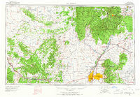
~ Albuquerque NM topo map, 1:250000 scale, 1 X 2 Degree, Historical, 1963, updated 1965
Albuquerque, New Mexico, USGS topographic map dated 1963.
Includes geographic coordinates (latitude and longitude). This topographic map is suitable for hiking, camping, and exploring, or framing it as a wall map.
Printed on-demand using high resolution imagery, on heavy weight and acid free paper, or alternatively on a variety of synthetic materials.
Topos available on paper, Waterproof, Poly, or Tyvek. Usually shipping rolled, unless combined with other folded maps in one order.
- Product Number: USGS-5386410
- Free digital map download (high-resolution, GeoPDF): Albuquerque, New Mexico (file size: 17 MB)
- Map Size: please refer to the dimensions of the GeoPDF map above
- Weight (paper map): ca. 55 grams
- Map Type: POD USGS Topographic Map
- Map Series: HTMC
- Map Verison: Historical
- Cell ID: 68640
- Scan ID: 189542
- Imprint Year: 1965
- Woodland Tint: Yes
- Aerial Photo Year: 1963
- Field Check Year: 1963
- Survey Year: 1961
- Datum: NAD27
- Map Projection: Universal Transverse Mercator
- Map published by United States Geological Survey
- Map Language: English
- Scanner Resolution: 600 dpi
- Map Cell Name: Albuquerque
- Grid size: 1 X 2 Degree
- Date on map: 1963
- Map Scale: 1:250000
- Geographical region: New Mexico, United States
Neighboring Maps:
All neighboring USGS topo maps are available for sale online at a variety of scales.
Spatial coverage:
Topo map Albuquerque, New Mexico, covers the geographical area associated the following places:
- Moquino - Rio Rancho - Guachupangue - Kemp (historical) - Rivajana - Corrales - San Pedro - Seboyeta - Pojoaque - Edgewood - Whitehorse - San Ildefonso Pueblo - Sandia Knolls - Española - North Valley - Rio Rancho Estates - Upper Frijoles Crossing - Diamond Tail Ranch - Hyer - Ranchos des Placitas - Encinal - Sandia Heights - Deer Creek Landing - San Antonio - Dos Tristes - Cuyamungue - Totavi - Tinian - McCartys - Frijoles - La Madera - Agua Fria - San Pedro Creek - Jemez Pueblo - El Dado - Los Duranes - Ortiz (historical) - Alameda - Laguna - San Fidel - Villa de Cubero - Milan - Santa Ana Pueblo - Los Candelarias - Kirtland Addition - Sundance Mesa - Frost (historical) - Herrera - Seama - Coyote (historical) - Cedar Grove - Chelwood Park - Las Dos - Hahn - Algodones - Buena Ventura - Gilman - Fruitvale (historical) - Las Cocinitas (historical) - Puertecito - Hospah - Armijo - Cedar Crest - Cochiti Lake - Cebolletita - Casa Blanca - Waldo (historical) - Señorito - Piedra Lumbre - Puesta Del Sol - Placitas - Los Cerrilos - Gallegos - Eagle Nest - P Simmons Place - LaVentana - Canyon Estates - La Bajada - Chical - Santa Cruz - San Rafael - Zia Pueblo - Horton Place - South Valley - New York - Puye - Las Huertas - Sandia Park - Santo Domingo Pueblo - Seven Springs - Sandia Pueblo - Acomita Lake - San Luis - San Pablo - San Felipe Pueblo - Dolores (historical) - Cieneguilla - Hagan (historical) - Tejon (historical) - O'Neil Landing
- Map Area ID: AREA3635-108-106
- Northwest corner Lat/Long code: USGSNW36-108
- Northeast corner Lat/Long code: USGSNE36-106
- Southwest corner Lat/Long code: USGSSW35-108
- Southeast corner Lat/Long code: USGSSE35-106
- Northern map edge Latitude: 36
- Southern map edge Latitude: 35
- Western map edge Longitude: -108
- Eastern map edge Longitude: -106


