
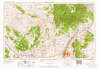
~ Albuquerque NM topo map, 1:250000 scale, 1 X 2 Degree, Historical, 1962
Albuquerque, New Mexico, USGS topographic map dated 1962.
Includes geographic coordinates (latitude and longitude). This topographic map is suitable for hiking, camping, and exploring, or framing it as a wall map.
Printed on-demand using high resolution imagery, on heavy weight and acid free paper, or alternatively on a variety of synthetic materials.
Topos available on paper, Waterproof, Poly, or Tyvek. Usually shipping rolled, unless combined with other folded maps in one order.
- Product Number: USGS-5386406
- Free digital map download (high-resolution, GeoPDF): Albuquerque, New Mexico (file size: 20 MB)
- Map Size: please refer to the dimensions of the GeoPDF map above
- Weight (paper map): ca. 55 grams
- Map Type: POD USGS Topographic Map
- Map Series: HTMC
- Map Verison: Historical
- Cell ID: 68640
- Scan ID: 189540
- Woodland Tint: Yes
- Aerial Photo Year: 1953
- Edit Year: 1962
- Field Check Year: 1954
- Datum: Unstated
- Map Projection: Transverse Mercator
- Map published by United States Geological Survey
- Map Language: English
- Scanner Resolution: 600 dpi
- Map Cell Name: Albuquerque
- Grid size: 1 X 2 Degree
- Date on map: 1962
- Map Scale: 1:250000
- Geographical region: New Mexico, United States
Neighboring Maps:
All neighboring USGS topo maps are available for sale online at a variety of scales.
Spatial coverage:
Topo map Albuquerque, New Mexico, covers the geographical area associated the following places:
- Forest Park - Five Points - Cedar Grove - Milan - LaVentana - Leon - Toltec - Pueblo of Sandia Village - Riverside - Fruitvale (historical) - Juan Tomas - Cañon - Marmon - Pines - Bibo - North Valley - Cañada Village - Laguna - Rivajana - Primera Agua - Casa Blanca - Hahn - Deer Lake - Angostura - Marquez - Albuquerque - New Laguna - Española - Horton Place - Los Ranchos de Albuquerque - Tinen Place - Mesa Village - Pojoaque - La Cuesta - Cuervo Crossing - Cedar Crest - Ortiz (historical) - San Antonito - P Simmons Place - Gallegos - Seboyeta - Montezuma (historical) - Desert Mountain - Puesta Del Sol - Los Duranes - Johns Place - Ranchos des Placitas - Ranchito - Bland - Edgewood - Jacona - El Chapparal - Anasazi Trails - Chelwood Park - Ambrosia Lake - Rincon - Casa Salazar - Alaska - Armijo - Herrera - El Tablazon - San Fidel - San Rafael - Dennis Chaves Estates - Old Town - Bernalillo - Madrid - Cavasos Place - Gilman - Domingo - Puertecito - La Cueva - Monticello - Totavi - Las Cocinitas (historical) - Chical - San Pedro Creek - Casa Loma - Cabezon - Sierra Vista Estates - Seven Lakes - San Jose - Moquino - Cuyamungue - Sandia Vista - Paraje - Rancho Valle - Waldo (historical) - Santa Clara - Cañoncito - Kirtland Addition - La Gotera - Alameda - Zamora - Mesita - Upper Frijoles Crossing - Rosario - Los Pastores - Sile - Buena Ventura
- Map Area ID: AREA3635-108-106
- Northwest corner Lat/Long code: USGSNW36-108
- Northeast corner Lat/Long code: USGSNE36-106
- Southwest corner Lat/Long code: USGSSW35-108
- Southeast corner Lat/Long code: USGSSE35-106
- Northern map edge Latitude: 36
- Southern map edge Latitude: 35
- Western map edge Longitude: -108
- Eastern map edge Longitude: -106


